



Quick Facts:
- Order: The Malheur National Forest closure order is Emergency Closure, Second Flat Fire Two, number 06-04-02-26-15.
- Effective: July 28, 2026 through December 31, 2026, unless rescinded sooner.
- District: Emigrant Creek Ranger District, Malheur National Forest.
- Fire size: 100,673 acres, 6 percent contained as of July 29.
- Closed: 4 campgrounds, 4 trails, 1 overlook, plus FS Roads 41 and 47, and the list is not exhaustive.
- Still open: All roads bordering the closure, including US 395, remain open to thru-traffic.
- Penalty: Up to $5,000 for an individual, $10,000 for an organization, or six months in prison.
- Also in force: Stage C public use restrictions and IFPL IV shutdown district-wide.
- Best for: Overlanders, OHV riders and dispersed campers with eastern Oregon plans.
8 min read
In This Guide
- What the Malheur National Forest Closure Covers.
- The Malheur National Forest Closure Order at a Glance.
- The Line Every Driver Should Read First.
- Closed Campgrounds, Trails and Roads.
- Malheur National Forest Fire Restrictions Beyond the Closure.
- What Entering a Closed Area Costs.
- Where It Stays Legal to Camp and Ride.
- Verify Before You Leave.
- What This Means for Your Trip.
- Frequently Asked Questions.
What the Malheur National Forest Closure Covers
The Malheur National Forest closure expanded on July 28, 2026, as the Second Flat Fire pushed past 100,000 acres in Harney County. Forest Supervisor Ann Niesen signed Order 06-04-02-26-15. It rescinds and replaces the earlier order, and it now runs through December 31 unless conditions improve first.
The fire started Friday, July 24 at 3:53 p.m., after a lightning storm dropped hundreds of strikes across northern Harney County. It ran roughly 12 miles in seven hours. As of the July 29 InciWeb update, it covers 100,673 acres at 6 percent containment with 269 personnel assigned. The cause remains undetermined. Notably, BLM Burns District manages the incident while the Forest Service issued the Malheur National Forest closure, because the fire crosses both jurisdictions.
For overlanders, OHV riders and dispersed campers, the practical stakes are specific. The order shuts four campgrounds, four trails and an overlook. Sections of two Forest Service roads go with them. Meanwhile, the surrounding highway network stays open. A second layer of Oregon fire restrictions then applies across the whole ranger district, inside the closure or not.
This guide covers what the order prohibits, what it exempts, and what it costs to ignore. It also gives an honest picture on alternatives. Because Oregon fire restrictions blanket the eastern half of the state right now, the alternatives section runs shorter on promises and longer on verification steps than it would in a normal August.
The Malheur National Forest Closure Order at a Glance
| Field | Detail |
|---|---|
| Order number | 06-04-02-26-15 |
| Replaces | Order 06-04-02-26-14, now rescinded |
| Legal authority | 16 U.S.C. 551 and 36 CFR 261.50(a) and (b) |
| Effective window | July 28 through December 31, 2026 |
| Signed by | Ann Niesen, Forest Supervisor |
| Forest Service contact | SM.FS.malpubinfo@usda.gov |
| Fire information line | 541-970-7130, 8 a.m. to 8 p.m. |
Specifically, four prohibitions apply inside the boundary. First, entering or being upon the closed area under 36 CFR 261.53(e). Second, being on a National Forest System road under 261.54(c) and (e). Third, being on a National Forest System trail under 261.55(a). Finally, operating a vehicle off National Forest System roads under 261.56.
However, two exemptions exist. Officials and organized rescue or firefighting personnel on duty qualify for the first. Permit holders carrying Forest Service Permit FS-7700-48 qualify for the second. No general recreation exemption exists, so a valid OHV sticker or camping reservation grants you nothing here.
The Line Every Driver Should Read First
Buried in the order sits the single most useful sentence for anyone routing through the region: “All roads bordering the closure area remain open to thru-traffic and are not impacted by this closure.”
In practice, US 395 stays open. The closure boundary follows Forest Service roads and the forest boundary, then runs along US 395 between roughly T. 20 S, R. 31 E and T. 21 S, R. 31 E. Therefore driving the highway past the fire is legal, while turning off it onto the closed forest roads is not.
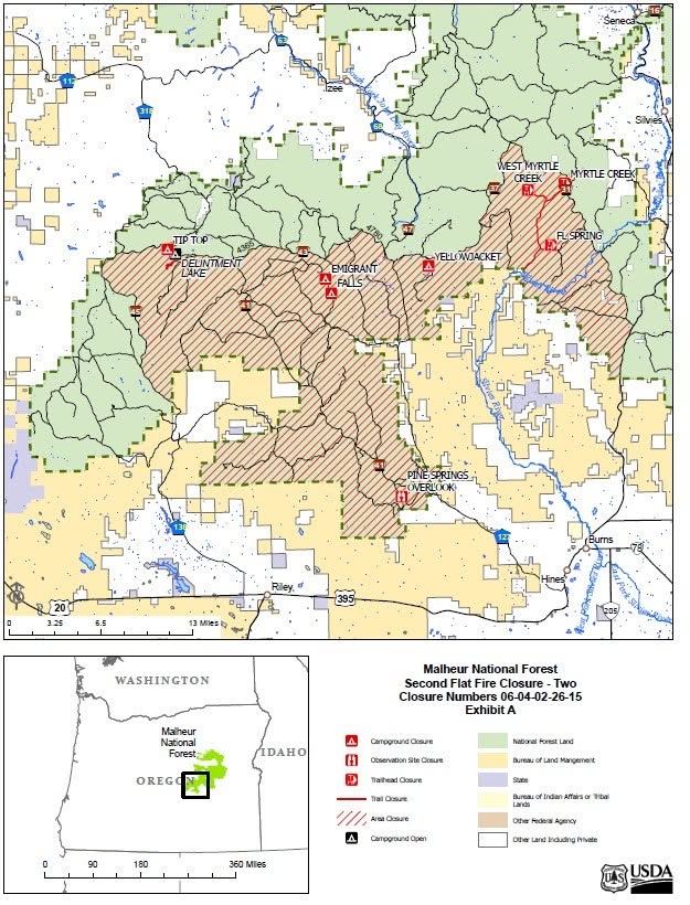
The boundary itself is written in township, range and section notation, which is useless at highway speed. Consequently the Forest Service publishes a closure map PDF alongside the order. Download it before you lose signal, because Harney County coverage is thin and the boundary follows road junctions rather than anything visible from the driver’s seat.
Safety note: A 100,673-acre fire at 6 percent containment moves with the wind, and closure boundaries expand faster than signage appears. Never treat an absent gate or sign as permission. If you meet fire traffic, heavy equipment or an air attack operating overhead, turn around immediately rather than continuing to a boundary you expect further on.
Closed Campgrounds, Trails and Roads
The order names nine recreation sites plus two road segments. Critically, it names them with the phrase “include but not limited to,” so the list is a sample rather than a complete inventory. Any site inside the boundary is closed whether the order names it or not.
Four campgrounds lose access: Emigrant, Yellowjacket, Tip Top and Falls. Four trails follow: FL Springs, West Myrtle Creek, Myrtle Creek and Delintment Creek. Additionally, the order closes Pine Springs Overlook Observation Site.
| Road or site | Closed segment |
|---|---|
| FS Road 41 | Junction of FSR-4120 north to the junction with FSR-4335 |
| FS Road 47 | Within the closure boundary. The order’s own wording is circular, so use the closure map |
| Yellowjacket Campground | The entire campground |
| Emigrant, Tip Top, Falls campgrounds | Closed in full |
| FL Springs, West Myrtle Creek, Myrtle Creek, Delintment Creek trails | Closed in full |
| Pine Springs Overlook | Closed in full |
Meanwhile, the wider boundary traces FSR-31, 37, 47, 4780, 43, 4365, 41 and 45S. Because those numbers describe a perimeter rather than a list of closed roads, every road inside the perimeter is closed regardless of whether the order names it. Reading the map matters more than reading the list.
Malheur National Forest Fire Restrictions Beyond the Closure
Most coverage stops at the closure. However, the Emigrant Creek Ranger District currently sits under three stacked orders, and stepping outside the closure boundary escapes only one of them.
Stage C public use restrictions, Order 06-04-02-26-09, apply district-wide. Under them, every campfire is out, including charcoal and solid fuel. It permits stoves and lanterns only on propane or pressurized liquid fuel with an on and off switch, inside a three-foot cleared circle. Smoking works only in an enclosed vehicle, a building, a recreation site, or a cleared three-foot patch. Generators need a spark arrestor and a ten-foot cleared diameter. Stage C also prohibits chainsaws, welding, torches and explosives outright, plus all vehicle travel off National Forest System roads.
Industrial Fire Precaution Level IV, a general shutdown, has applied since July 27. Fire danger reads Extreme in both zones. In short, the Malheur National Forest fire restrictions outside the closure break a normal camp routine in several places. Our guide to 2026 fire restrictions across the Western US explains how these stages work.
What Entering a Closed Area Costs
Notably, the penalty appears in the order itself. Violations carry a fine of up to $5,000 for an individual or $10,000 for an organization, imprisonment of up to six months, or both, under 16 U.S.C. 551 and 18 U.S.C. 3551, 3571 and 3581.
Those numbers are statutory maximums rather than typical outcomes. A 261.53(e) violation is a Class B misdemeanor, and most result in a mandatory-appearance federal violation notice before a U.S. Magistrate. No verified source publishes an average fine, so treat “up to $5,000” as the honest ceiling and ignore any figure quoted more precisely.
For most readers, though, the financial exposure is not the real cost. Entering an active fire area risks rescue-cost liability, and a single vehicle inside the perimeter grounds air attack while crews confirm who is down there. For a fire at 6 percent containment, an hour of grounded air attack costs more acres than any fine reflects.
Where It Stays Legal to Camp and Ride
Normally this section would list three nearby forests and send you on your way. Late July 2026 does not allow it. Nearly every adjacent unit carries its own active closure or elevated restriction, and several published “open” status pages date to June and contradict late-July orders.
| Unit | Status as of July 29, 2026 |
|---|---|
| Ochoco NF | Stage 2 forest-wide; multiple fire closures through Dec 31 |
| Deschutes NF | Stage 2 forest-wide including wilderness, through Nov 30 |
| Wallowa-Whitman NF | Phase C; campfires banned even in developed campgrounds; Salmon and Olive Butte, Burnt Creek and Anthony fire closures active |
| Umatilla NF | Phase C through Oct 1; four fire closures active |
| BLM Prineville | Closures cover nearly all district lands as of July 27 |
| BLM Vale | Emergency area closures issued July 28; Level 2 restrictions elsewhere |
| BLM Burns | Two roads closed July 28: Stinkingwater Access and Stinkingwater to Warm Springs. July 10 fire prevention order stands |
| Fremont-Winema NF | Least restricted found: Stage 1, and no fire area closure located |
The One Unit Still at Stage 1
Fremont-Winema National Forest is the only unit in the region we found at Stage 1 rather than Stage 2 or Phase C, and the only one with no fire area closure. Even so, verify it on the day you leave rather than trusting this table, since these orders change weekly.
OHV Systems: Closed Versus Unverified
Two clarifications on OHV systems matter here. Green Mountain is closed outright: Ochoco order 06-07-01-26-04 is named for the Brewer, Crosswhite West and Green Mountain fires and runs through December 31. Millican Valley and East Fort Rock are different cases, where the trail page still reads open and a later district-wide order says otherwise. For those two, call BLM Prineville at 541-416-6700 or Deschutes NF before committing.
Meanwhile, anyone willing to move west should read our breakdown of Stage 2 fire restrictions in Central Oregon first, since the rules differ from Stage C in ways affecting stoves and generators. For trip planning further out, our guide to the best off-road trails in Oregon and our roundup of free dispersed camping in Oregon both cover ground well outside the current fire footprint.
Verify Before You Leave
Closure boundaries in an active fire season change faster than any article updates. Therefore build a five-minute check into the morning you leave.
Start with the Malheur National Forest alerts page, which carries the current order and both PDFs. Next, check the incident page on InciWeb for acreage, containment and any new evacuation zone. Then call 541-970-7130 between 8 a.m. and 8 p.m. for anything the pages leave ambiguous. Finally, confirm your specific road on the Motor Vehicle Use Map, because a road open under the forest order stays closed if it was never open to your vehicle class. Our guide on reading MVUMs to find legal dispersed campsites walks through it.
One reason to check late rather than early: InciWeb’s 72-hour outlook forecasts critical fire weather Saturday, with gusts of 30 to 35 mph and single-digit humidity. The agency expects this boundary to move.
Download the closure map, the MVUM and your route offline before leaving pavement. Signal across Harney County is unreliable, and a boundary you cannot see on a screen is a boundary you will cross by accident.
What This Means for Your Trip
If your plans involved Emigrant, Yellowjacket, Tip Top or Falls campground, or the Myrtle Creek trail network, the Malheur National Forest closure ends them until at least December 31. No workaround exists, and no permit available to recreational users changes it.
If your route simply passes through, you are fine. US 395 and every other road bordering the closure remain open to thru-traffic. Stop for fire traffic, skip the scenic detour, and keep moving.
If you wanted to relocate somewhere else in eastern Oregon, lower your expectations. Stage 2, Phase C and Level 2 restrictions blanket the region, campfires are gone almost everywhere, and off-road travel is prohibited district-wide on the Malheur regardless of the closure boundary. Fremont-Winema is the softest landing we located, though it still carries Stage 1 rules.
The broader lesson for the season is procedural. Check the order, not the campground page. Read the map, not the road list. Call the district on the morning you leave. Fire seasons like this one punish planning done a week in advance, and eastern Oregon has another two months to run.
Frequently Asked Questions
Is the Malheur National Forest closed?
Not entirely, but more of it is closed than one order suggests. Order 06-04-02-26-15 closes a defined area of the Emigrant Creek Ranger District through December 31, 2026. Two further Malheur closures also run: the Salmon and Olive Butte order 06-04-01-26-13, and the Egypt Fire order 06-04-02-26-12, which closes its own segment of FSR 41 through December 31. District-wide Stage C restrictions and an IFPL IV shutdown apply on top of all three.
Which campgrounds are closed by the Second Flat Fire closure?
Four campgrounds are closed: Emigrant, Yellowjacket, Tip Top and Falls. The order also closes FL Springs, West Myrtle Creek, Myrtle Creek and Delintment Creek trails, plus Pine Springs Overlook Observation Site and segments of FS Roads 41 and 47. The order lists these sites as examples, not as a complete inventory, so anything inside the boundary is closed.
What is the fine for driving into a closed National Forest area?
Up to $5,000 for an individual or $10,000 for an organization, plus imprisonment of up to six months. Those figures are statutory maximums under 16 U.S.C. 551 and 18 U.S.C. 3551, 3571 and 3581. A violation is a Class B misdemeanor, usually handled by a mandatory appearance before a U.S. Magistrate.
Is OHV and 4×4 travel still allowed on the Malheur National Forest?
Not off designated roads. Stage C restrictions prohibit vehicle use off National Forest System roads across the entire Emigrant Creek Ranger District, separately from the fire closure. Inside the closure boundary, all road and trail travel is prohibited outright.
Is US 395 open through the closure area?
Yes. The order states all roads bordering the closure area remain open to thru-traffic. US 395 forms part of the eastern boundary, so through travel is legal while turning onto closed forest roads is not.
Where is the Malheur National Forest closure map?
The Forest Service publishes a closure map PDF alongside the order on the Malheur National Forest alerts page. Download it before you leave cell coverage, because the written boundary uses township and range notation rather than landmarks.
Related Reading
- Boundary Waters Closure 2026: What’s Shut, What Reopened, and What to Do Next.
- Designated Dispersed Camping: What the 2026 National Forest Shift Means for You.
- The New Forest Service App: What It Means for Off-Roaders and Campers.
- Off-Road Vehicles on National Forests: What the New Federal Order Means.