


Quick Facts:
- Topic: Reading a Motor Vehicle Use Map (MVUM) to find legal dispersed campsites
- Skill level: Beginner to intermediate overlander or camper
- Time to learn: About 30 minutes to read a map confidently
- Tools needed: Free MVUM PDF, a phone app like Avenza or onX, a backup paper map
- Cost: Free; most dispersed camping carries no fee and no permit
- Legal basis: 2005 Travel Management Rule, 36 CFR Part 212
- Core rule: Only routes printed on the MVUM are open to motor vehicles
- Best for: Anyone who wants to find dispersed camping without risking a ticket
11 min read
In This Guide
- Why the MVUM Comes First
- What Is an MVUM?
- Key Numbers at a Glance
- Why the MVUM Is the Law, Not a Suggestion
- How to Read an MVUM Step by Step
- How to Get an MVUM and Use It Offline
- How to Find Dispersed Camping in Seven Steps
- Dispersed Camping Rules to Know Before You Go
- MVUM vs. Visitor Map vs. Topo
- Common Mistakes Behind Most Fines
- Camp Clean: Leave No Trace
- How to Find Dispersed Camping: Your Checklist
- Frequently Asked Questions
Why the MVUM Comes First
If you want to learn how to find dispersed camping on public land, the Motor Vehicle Use Map is your starting point. This free black-and-white map shows every road and trail a national forest has opened to motor vehicles. Skip it, and a quiet spur road off the highway might already be illegal to drive.
Most overlanders learn the hard way. They follow a track on a phone map, set up camp, and later find out the route was never legal for vehicles. The MVUM removes the guesswork because it is the document a ranger checks. Once you read one fluently, you find better sites faster and avoid fines.
This guide breaks the skill into plain steps. First, you will learn what the map is and why it carries legal weight. Next, you will decode the symbols, the vehicle classes, and the camping corridors. Finally, you will walk through a repeatable workflow for picking a legal site. For a broader primer on the lifestyle itself, our companion piece on dispersed camping covers gear and trip planning.
What Is a Motor Vehicle Use Map?
An MVUM is the official document each national forest publishes to show where motorized travel is allowed. The U.S. Forest Service created the system under the 2005 Travel Management Rule, written into federal regulation at 36 CFR Part 212. Every forest with a road network produces one.
The map shows three things: designated roads, designated trails, and any areas opened to motor vehicles. Alongside each route, a table lists the vehicle classes allowed and the season of use. The sheet itself stays deliberately plain, printed in black and white with no topographic detail and no campground icons.
Because the map omits terrain, the Forest Service is clear about one point: an MVUM does not serve as your main navigation tool. Pair it with a visitor map or a topo layer for route finding. The MVUM answers a narrower question instead, which is whether a given road is legal for your rig today.
Key Numbers at a Glance
The figures below show up constantly in dispersed camping rules. Treat them as common examples, not universal law, because each forest and each Bureau of Land Management field office sets its own limits. Always confirm the numbers for your specific destination before you roll out.
| Rule | Common Figure (verify locally) |
|---|---|
| Stay limit before you move | Usually 14 days, often within a 28 or 30 day window |
| Move distance after the limit | 5 to 30 miles, set by the forest or office |
| Drive-off corridor to reach a camp | 150 ft (Gifford Pinchot) or 300 ft (Deschutes), where designated |
| Camp distance from water | 100 to 200 ft, depending on agency |
| Road definition (vs. trail) | Over 50 inches wide; trails are 50 inches or less |
| Map update schedule | Reviewed at least annually, often January |
| Cost | Free map; free dispersed camping in most areas |
Why the MVUM Is the Law, Not a Suggestion
The forest road network runs on a simple principle: closed unless open. Routes missing from the MVUM stay closed to public motor vehicle travel, even when a worn two-track sits right in front of you.
This flips the old assumption many drivers still carry. Before the Travel Management Rule, much of the network ran as open unless posted closed. Today the system is designated, so the burden sits on you to confirm a route is legal. A missing sign on the ground offers no defense.
The Forest Service calls the MVUM an enforcement tool, and officers issue violations any time after the map goes public. Designated routes will not always carry a sign in the field, yet they appear on the map. Because of this, federal policy on motorized access on national forests places responsibility on the driver to carry and read the current map.
How to Read an MVUM Step by Step
Reading an MVUM looks intimidating at first because the legend is dense. Break it into four parts, though, and the map turns readable in minutes. Work through the line types, the vehicle classes, the seasonal dates, and the camping corridors in order.
Line types and route numbers
Every route on the map carries a Forest Service number, and each number keys to a row in the accompanying table. Find your road by its number, then read across to see what it allows. The map shows roads and trails with distinct line symbols, but the exact meaning of each line style lives in your map’s own legend.
Do not assume a fixed solid-equals-road convention across forests. Instead, read the legend printed on the sheet you downloaded. The national symbology standard sets the categories, while each map labels them locally.
Vehicle class designations
The heart of the legend is vehicle class. A typical map separates routes into a handful of categories. Some roads open to highway-legal vehicles only, meaning licensed and street-legal rigs. Others open to all vehicles, including unlicensed machines like a side-by-side.
Trails split the same way. A trail might allow vehicles 50 inches or less, which covers most ATVs and dirt bikes. Separate symbols cover full-size trails built for 4x4s, plus motorcycle-only single track. Match the symbol beside your route to your rig before you commit.
One Forest Service caution is worth repeating: legal does not mean prudent. A low-standard road might legally permit any vehicle, including a passenger car, even when driving it in a sedan would be unwise. Read the maintenance level and scout before you trust a remote spur.
Seasonal date ranges
Many routes open only during part of the year. The table lists a season of use beside each road number, often as a date window. Forests close routes seasonally to protect wildlife, to keep drivers off impassable mud, and to limit damage to soil and water.
Check the dates every trip, since a road open in August might sit closed in April. A route with no listed dates is generally open year-round, but confirm against the legend rather than guessing.
The dispersed camping corridor
This symbol is the one most overlanders miss, and it matters most for camping. Where a forest designates motorized access for dispersed camping, the map flags specific roads with a corridor symbol. Along those roads only, you are free to pull a short distance off the route to reach a site.
The distance varies by forest. Gifford Pinchot National Forest allows 150 feet off a designated road on an existing route. Deschutes and Ochoco National Forests allow up to 300 feet, plus a rule to park at least 30 feet from water. Where no corridor symbol appears, you stay on the road and walk in.
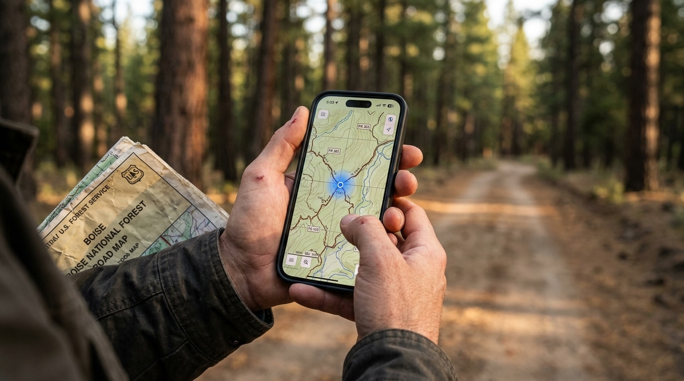
How to Get an MVUM and Use It Offline
Every MVUM is free, and forests must post them online. Start at the forest’s Maps and Publications page, then download the PDF for your ranger district. Paper copies often sit at the local visitor center or ranger station too, which makes a smart backup when batteries die.
For field use, georeferenced apps beat a folded sheet. The free Avenza Maps app loads official MVUM PDFs and plots your live position with your phone’s GPS, even with no cell signal. Its blue dot works off satellite, so you watch yourself approach a legal corridor in real time.
Other tools layer the same data with terrain. onX Offroad publishes a dispersed camping layer drawn from MVUM data, and Gaia GPS overlays interactive Forest Service motor vehicle layers on topo bases. Our roundup of the best off-road GPS and navigation apps compares the offline features in depth. Whatever you pick, download the maps before you lose service.
How to Find Dispersed Camping in Seven Steps
Here is the repeatable workflow for how to find dispersed camping legally. Run these steps in order, and you turn a blank forest into a shortlist of legal, comfortable sites before you ever leave home.
- Pick a forest or district. Confirm the forest allows dispersed camping there, with no posted closure or developed-area buffer in the way.
- Download the current MVUM. Grab the PDF for your district, and double-check the year so you are reading current designations.
- Read the legend and table. Identify open roads for your vehicle class, note seasonal dates, and flag the roads marked with a dispersed camping corridor symbol.
- Cross-reference satellite and topo. Overlay an app or Google Earth to spot flat, established pullouts near the legal corridors, and to confirm you are on public land, not a private inholding.
- Check fire rules and permits. Look up current fire restrictions and any required permit, such as the year-round California Campfire Permit.
- Save offline maps and waypoints. Download the area, drop pins on two or three candidate sites, and mark your last point with cell coverage.
- Scout on arrival. Stay on the designated route, enter a corridor only where designated, and use an existing site with a fire ring rather than crushing new ground.
The payoff compounds with practice. After a few trips, you will read a district map in a coffee break and arrive with a primary site and a backup already chosen.
Dispersed Camping Rules to Know Before You Go
Dispersed camping means camping outside a developed campground with no services: no water spigot, no toilet, no trash pickup. The Forest Service allows it in most areas not closed or developed. On the other side of the fence, BLM dispersed camping stays open unless a sign closes the area to camping.
Stay limits vary widely, so confirm yours locally. The Forest Service usually caps stays near 14 days, then asks you to move. Move distances differ by unit: Caribou-Targhee National Forest sets 5 road miles, while North Carolina forests bar a return within 10 miles. BLM dispersed camping commonly allows 14 days within 28, then a move of roughly 25 to 30 miles.
Water buffers and fire rules differ too. Pacific Southwest forests ask for a campsite 150 feet from water and a fire 100 feet from water, while Leave No Trace teaches a 200-foot buffer. California requires a free campfire permit year-round, even for a gas stove, though Oregon and Washington run no statewide equivalent. Check restrictions before every trip, since a dry summer changes the rules overnight.
MVUM vs. Visitor Map vs. Topo
These three maps serve different roles, and strong trip planning uses all three together. Confusing them is how drivers end up on illegal roads with a clean conscience.
The MVUM settles the legal question alone: which routes are open, to which vehicles, and when. A Forest Visitor Map handles orientation, showing the broader forest, landmarks, and facilities for navigation. Finally, a topo map fills in terrain, revealing elevation, drainages, and the flat benches where a good site hides.
Lean on each for its strength. Plan your route and scout campsite terrain on the visitor and topo layers, then verify every road against the MVUM before you drive it. Because the MVUM is the enforcement document, it wins any conflict between maps about whether a road is legal.
Common Mistakes Behind Most Fines

Most citations trace back to a short list of avoidable errors. Knowing them ahead of time keeps your trip clean and your record clean.
The biggest trap is trusting a consumer map app over the MVUM. A road shown on Google Maps or worn into the dirt is not automatically legal, because closed routes were often left physically open. Driving cross-country to a spot is another frequent violation, since you leave a road only inside a designated camping corridor on an existing route.
Other repeat offenders include ignoring seasonal closures, overstaying the day limit, camping too close to water or a developed area, and skipping a required fire permit. Blocking a road or gate earns attention fast as well. Notably, an unsigned route is still illegal if the map does not show it, so the map always settles the question.
Camp Clean: Leave No Trace
Dispersed camping stays free and open only while campers keep it clean. Land managers have closed some popular sites after trash and human waste piled up, so your habits protect everyone’s access. Pack out all trash, food scraps, and toilet paper, and never bury or burn your garbage.
For human waste, the Leave No Trace standard is a cathole 6 to 8 inches deep, set at least 200 feet from water, camp, and trails. Some areas now require you to pack waste out in a sealed bag, so check local rules first. Scatter dishwater at least 200 feet from any water source as well.
Choose a previously used site whenever possible, since new sites scar plants and soil. Use an existing fire ring, keep fires small, and drown the ashes until they are cold to the touch. Our full guide to Leave No Trace principles walks through each habit with overlanding-specific tips.
How to Find Dispersed Camping: Your Checklist
Pull the whole skill together with a quick pre-trip checklist. Before you leave the driveway, run down this list so nothing slips through the cracks.
- Downloaded the current MVUM PDF for your ranger district
- Confirmed the route is open to your vehicle class and in season
- Identified roads with a dispersed camping corridor symbol
- Loaded offline maps in Avenza, onX, or Gaia with your blue dot working
- Checked current fire restrictions and grabbed any required permit
- Chosen a primary site and a backup, both on existing ground
- Packed out gear for trash and human waste
With this routine, learning how to find dispersed camping shifts from stressful guesswork to a calm, repeatable habit. For a real-world example of applying these steps across a whole state, see our breakdown of free dispersed camping in Colorado. The map is the law of the land, and now you read it fluently.
Frequently Asked Questions
How do you find dispersed camping for free?
Start with the free MVUM for the national forest you want to visit, then look for roads marked with a dispersed camping corridor symbol. Cross-reference an app like onX or Avenza to spot existing pullouts. Most dispersed sites carry no fee and no reservation.
Is dispersed camping legal in national forests?
Yes. National forest dispersed camping works in most areas not closed or developed, as long as you reach the site legally. You stay on designated routes shown on the MVUM and only drive off a road where a camping corridor is designated.
Do you need a permit for dispersed camping?
Usually no. Free dispersed camping on Forest Service land generally needs no permit, and BLM dispersed camping rarely needs one either, though large groups sometimes do. Note: California requires a free campfire permit year-round for any fire, stove, or lantern.
What is the difference between an MVUM and a Forest Visitor Map?
The MVUM is the legal document showing which roads are open to motor vehicles, by vehicle class and season. A Forest Visitor Map, by contrast, works as a navigation aid showing the broader forest and landmarks. Either way, the MVUM settles any dispute about whether a road is legal.
How far off the road are you allowed to drive to camp?
Only where the MVUM designates a corridor, and only as far as the forest allows. Examples range from 150 feet at Gifford Pinchot to 300 feet at Deschutes. Without a corridor symbol, you park on the road and walk to your site.
How often are MVUMs updated?
Forests review the MVUM at least annually, often in January, to fix mapping errors and reflect new travel decisions. Always download the current year before a trip, because a road open last season might close this one.