



Quick Verdict: The best off road trails in Oregon stretch from Coast Range OHV loops to a 9,500-foot gravel summit above the Alvord Desert. Steens Mountain Loop Road and the Owyhee Canyonlands anchor the list for remote high desert driving. Browns Camp and La Dee Flats give newer drivers an easier start closer to Portland. For most stock rigs, Browns Camp is the smartest first trail. Hat Point Road and the Owyhee’s Three Forks Road sit at the remote, high-clearance end. Every trail below includes a custom topo map with mile markers and a USGS elevation profile.
Last updated: July 2026 | 13 min read
In This Guide
- How We Picked the Best Off Road Trails in Oregon
- All 11 Trails at a Glance
- Western Oregon Off-Road Trails: Coast to Cascade Summit
- Southeast Oregon Off-Road Trails: Steens Country and the Owyhee
- Northeast Oregon’s Off-Road Drive: Hat Point Road and Hells Canyon
- Pros and Cons of Wheeling Oregon
- Which Off Road Trails in Oregon Fit Your Rig?
- Final Verdict
- Frequently Asked Questions
How We Picked the Best Off Road Trails in Oregon
This guide maps 11 of the best off road trails in Oregon. The list runs from Coast Range dune riding to the deepest canyon in North America. Search demand backs up the picks, since Alvord Desert alone draws roughly 4,900 monthly searches, and Leslie Gulch and the Owyhee Canyonlands each pull well over 1,000. We weighted the list toward places drivers already search for, while still covering Oregon’s full geographic spread. We also weighed published difficulty, land-agency access rules, and driving distance from major cities before cutting the list to 11.
Each entry below includes one of 11 custom trail maps. We built every map from public USGS elevation data and OpenStreetMap route records. A polished graphic means nothing if the numbers behind it are wrong, which is why every trail here gets GPS-measured mileage, mile markers, and an elevation profile in feet. Several of these Oregon routes are open riding areas or trail networks, not one signed path. Where our mapped route covers the main access road instead of the full interior network, we say so directly in the trail notes.
Difficulty ratings follow the managing agency where one exists. We also back it up with a consensus of published trail guides. In practice, an “easy” rating here means a stock high-clearance vehicle finishes the route without drama. A “difficult” rating, in contrast, means remoteness, exposure, or rough tread pushes the trip beyond a casual outing. New to trail symbols? Our guide on how to navigate off-road trails like a pro covers the basics before you leave pavement. Similarly, our walkthrough on reading a Motor Vehicle Use Map confirms which forest roads stay legally open at each Oregon location below.
All 11 Trails at a Glance
| Trail | Mapped Miles | Difficulty | Region |
|---|---|---|---|
| Browns Camp Loop | 7.6 | Easy-moderate | Tillamook State Forest |
| Sand Lake Recreation Area | 2.9 | Easy | Oregon Coast |
| La Dee Flats OHV Area | 4.2 | Moderate | Mount Hood National Forest |
| McKenzie Pass (OR-242) | 36.5 | Easy-moderate, paved | Central Cascades |
| Paulina Peak Road | 4.1 | Easy-moderate | Newberry National Volcanic Monument |
| Christmas Valley Sand Dunes | 6.2 | Easy | South-Central Oregon |
| Steens Mountain Loop Road | 55.4 | Moderate | Southeast Oregon |
| Alvord Desert Access Route | 37.5 | Easy, remote | Southeast Oregon |
| Leslie Gulch Road | 14.2 | Easy-moderate | Southeast Oregon |
| Three Forks Road, Owyhee Canyonlands | 28.3 | Difficult, remote | Southeast Oregon |
| Hat Point Road | 22.8 | Moderate-difficult | Hells Canyon |
Before you air down on any of the trails above, here is how the three MORRFlate options in this guide compare, to help you pick the right one for your rig and group size.
| Best Overall | Best Value | Best Digital Control | |
|---|---|---|---|
| Product | TOP PICK MORRFlate TenSix MORRFlate TenSix |  MORRFlate Quad MORRFlate Quad |  MORRFlate Air Hub MORRFlate Air Hub |
| Rating | ★★★★★ 4.9 67 ratings | ★★★★☆ 4.6 130 ratings | ★★★★★ 5.0 8 ratings |
| Type | Compressor + 4-tire hose kit | 4-tire hose kit only, no compressor | Digital controller only, no compressor |
| Best For | Fastest air-up after every trail day | Budget-minded groups with an existing compressor | Precise PSI control on multi-vehicle trips |
| Price | $230.00 as of Oct 22, 2:01 am | $249.99 as of Oct 22, 3:48 am | |
| Check Price → | Check Price → | Check Price → |
Western Oregon Off-Road Trails: Coast to Cascade Summit
Western Oregon packs the widest terrain variety into the shortest driving distance from Portland, running from Coast Range dirt loops to a paved Cascades summit. These five routes make a good starting point if you want to sample the state without committing to a full weekend trip.
1. Browns Camp Loop
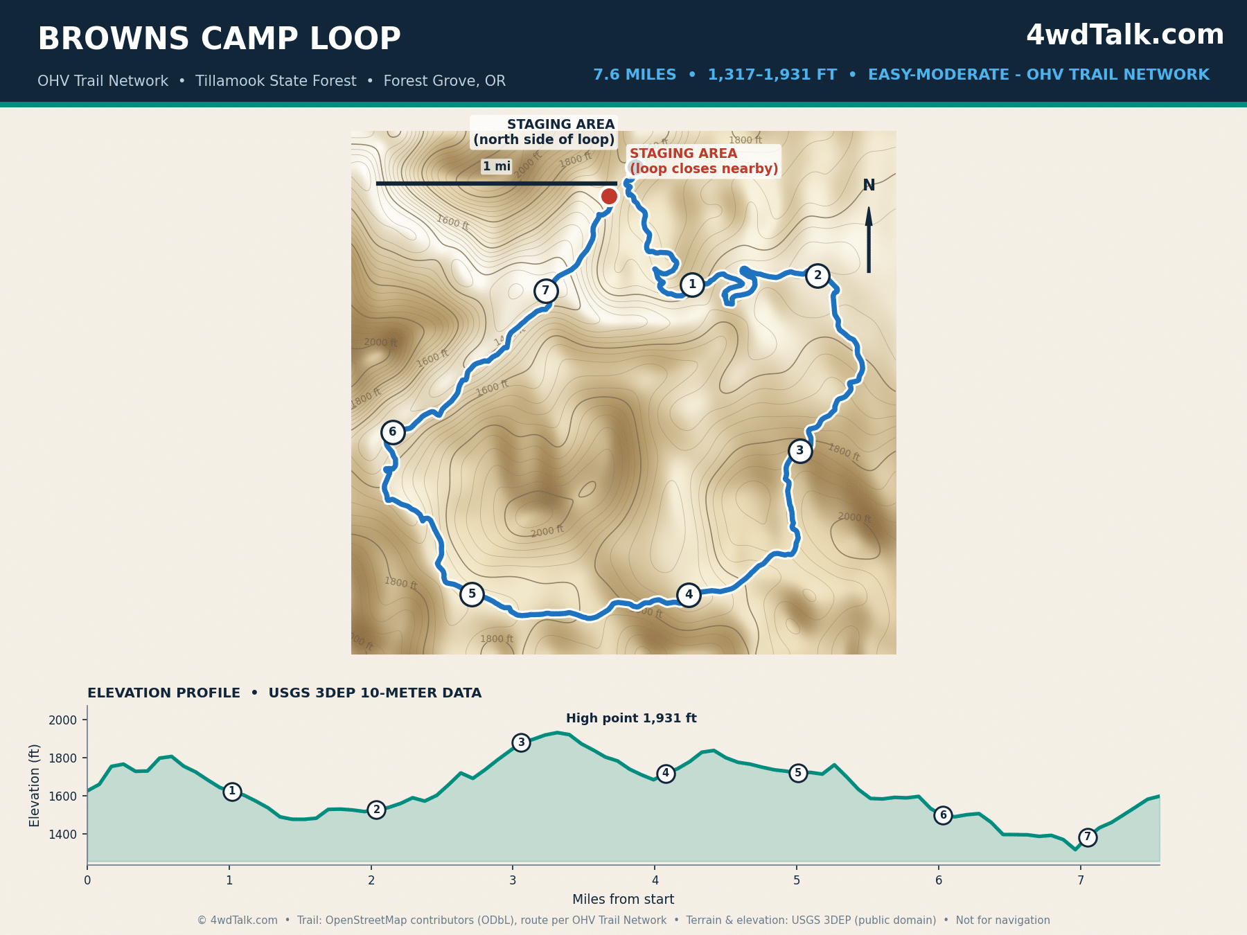
Browns Camp sits closer to Portland than any other trail on this list. Weekend traffic here proves it. The Oregon Department of Forestry manages more than 250 miles of trail across the wider Browns Camp, Jordan Creek, and Diamond Mill network in Tillamook State Forest. Our map covers one 7.6-mile loop within the network. No single route number describes the whole area, since the trails braid and reconnect constantly. For comparison, AllTrails lists a similar loop at 7.1 miles, close to our GPS-measured figure.
Terrain here mixes packed dirt, root sections, and mild grades instead of rock ledges. Stock trucks and side-by-sides both do fine. The trail network sprawls in every direction from the staging area. Download an offline map before you go, since cell signal disappears once you leave the parking lot.
2. Sand Lake Recreation Area
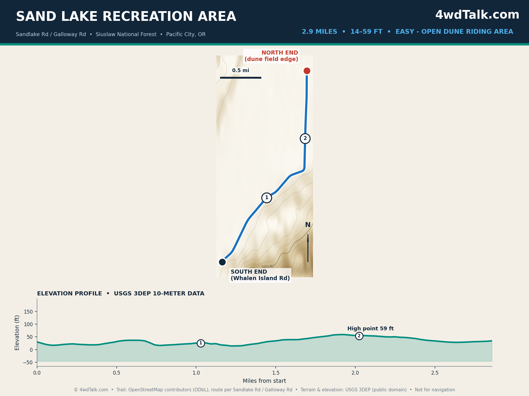
Sand Lake is the only ocean-front dune riding area on this list. The Forest Service puts the open sand at roughly 3.5 miles from the estuary northeast into the dune field. Riding stays largely unrestricted once you reach the sand. However, no dedicated OHV trail line exists in public map data for the open dunes themselves, so our map instead traces Sandlake Road, the verified public access corridor into the recreation area.
Low parabolic dunes near the entrance suit newer riders building confidence before the steeper faces farther north. Camp at East Dunes, Sandbeach, or West Winds. Check tide tables first, since the estuary crossing floods on incoming tides.
3. La Dee Flats OHV Area
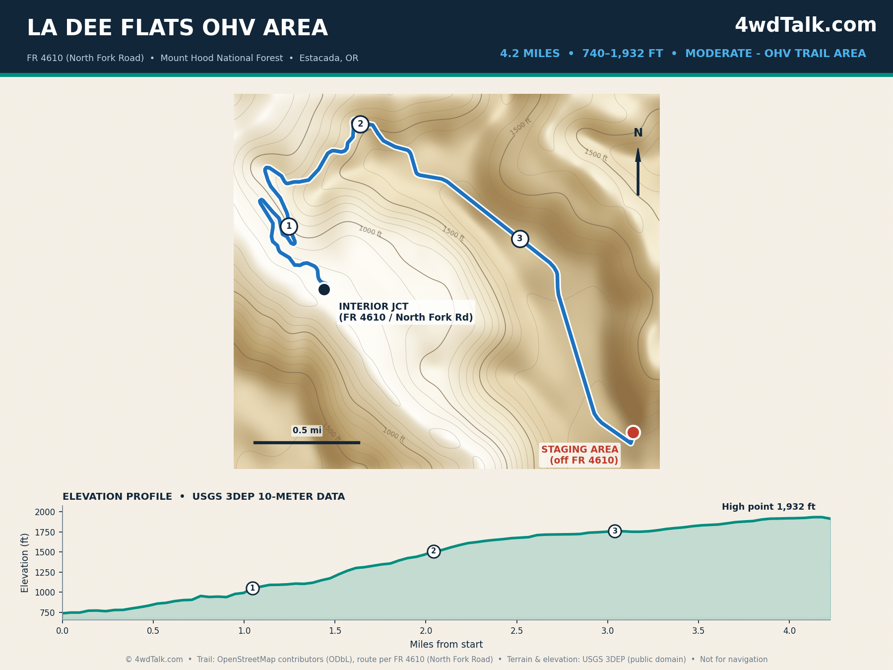
La Dee Flats sits in the Clackamas River Ranger District of Mount Hood National Forest, close enough to Estacada for a quick day trip from Portland. The Forest Service publishes roughly 28 miles of interior ATV trail here, while some independent trail-directory sites put the network closer to 30 or 35 miles. Public route data skips the interior log crawls and climbing loops entirely, so the map above instead traces Forest Road 4610, the named route into the staging area, which runs 4.2 miles and climbs almost 1,200 feet.
Riders describe the network as beginner-friendly near the entrance, with harder log crawls and rock sections farther in. Published difficulty notes support this wider range. Before your first visit, our guide to 4×4 recovery gear you need in your kit covers what to pack for the tougher interior loops.
4. McKenzie Pass (OR-242)
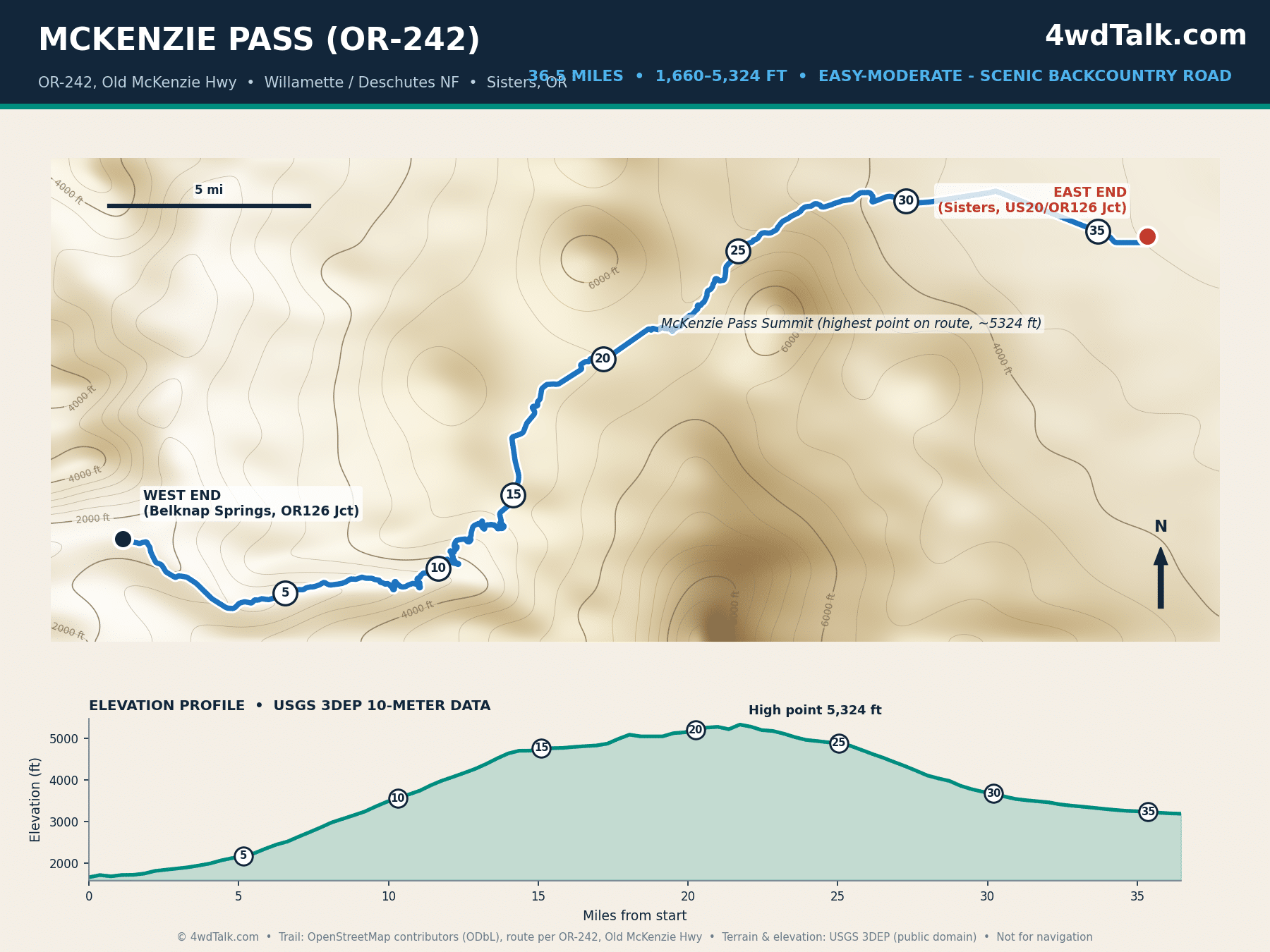
McKenzie Pass earns its spot through search volume and its place in the surrounding Cascades forest road network, not technical difficulty. OR-242 runs fully paved for its entire 36.5-mile length, climbing from Belknap Springs to a 5,324-foot summit before dropping into Sisters. Treat it as a scenic high-elevation backcountry drive suited to any vehicle in season, not a 4×4 trail. Instead, pair it with the unpaved Forest Service roads branching off the pass for the actual off-road mileage.
Snow closes the road from roughly November through late June, and gates sit several miles from each end. Once the road opens, the lava-field overlooks near the summit rank among the best roadside views in the state. Additionally, the drive connects naturally to the gravel forest roads around Santiam Pass to the north.
5. Paulina Peak Road
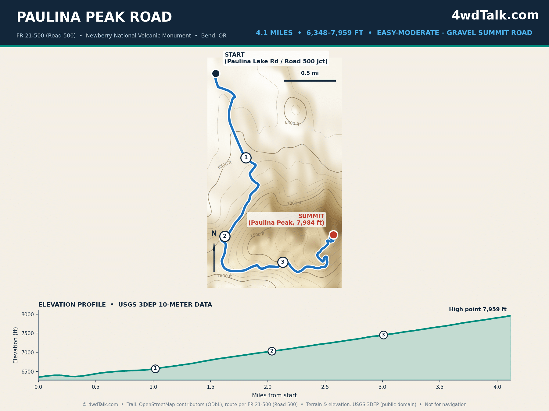
Paulina Peak Road climbs 4.1 gravel miles inside Newberry National Volcanic Monument, matching the Forest Service’s own driving directions almost exactly. The route gains close to 1,600 feet on its way to the 7,984-foot summit. From the top, the view takes in both crater lakes below and the full Cascade skyline on a clear day. However, the Forest Service describes the surface as steep, dusty, and rough in stretches. Treat the “easy-moderate” rating here as relative to true 4×4 trails, not a paved scenic road.
Road 500 climbs quickly through switchbacks near the top. Downshift early and give descending traffic room on the narrower sections. Bend sits closest by driving distance, per the Forest Service’s own directions.
Every trail in this guide starts the same way: airing down. A dual-cylinder compressor like the MORRFlate TenSix refills four 35s in minutes at the end of the day, so you spend daylight on the trail instead of waiting on a pump.
MORRFlate TenSix Off Road Air Compressor, 12 Volt Heavy Duty Tire Inflator
FAST 10.6 CFM INFLATION: Air up a set of 35″ tires in under 5 minutes when used with the MORRFlate multi-tire inflation and deflation kits.
- 10.6 CFM dual-cylinder output
- Fills four 35-inch tires in about 5 minutes
- Inflates and deflates four tires at once with the kit
- Overkill for a single daily driver staying on pavement
Southeast Oregon Off-Road Trails: Steens Country and the Owyhee
Cross the Cascades and the terrain changes completely. Southeast Oregon trades forest roads for open high desert, longer distances between fuel stops, and Oregon’s most remote backcountry driving. These five routes reward careful trip planning more than any others on this list.
6. Christmas Valley Sand Dunes
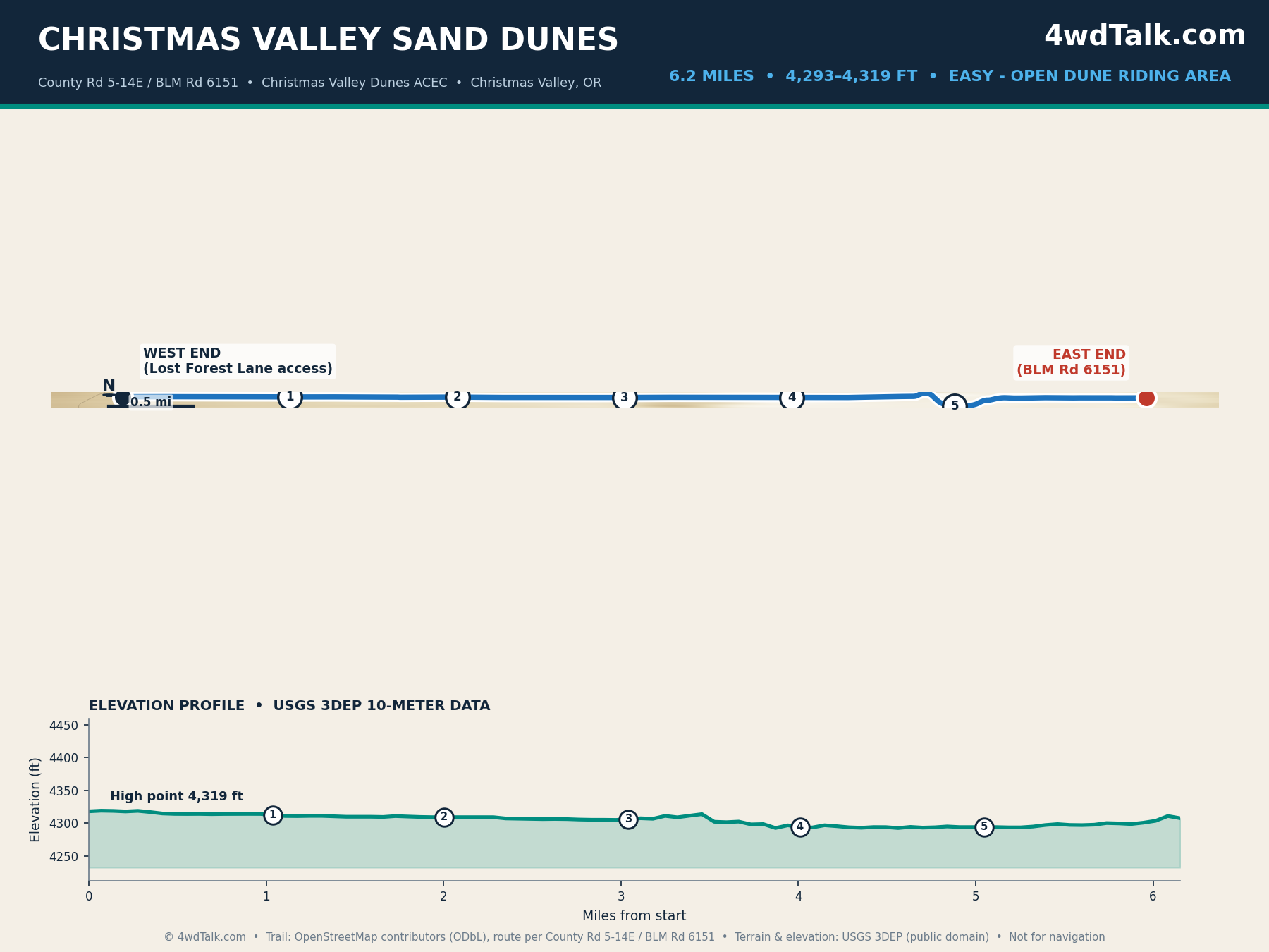
Nearly 8,900 acres of open dune riding sit inside the BLM’s Christmas Valley Sand Dunes Area of Critical Environmental Concern, southeast of the town of the same name. No single trail line covers the open sand itself. So the map above instead traces the named County Road 5-14E and BLM Road 6151 corridor. This matches the BLM’s own driving directions for the final two legs of the drive, a combined 7 miles ending at the Lost Forest area.
Flat basin terrain and gentle dune faces make this one of the most forgiving riding areas on the list. It suits families and riders building confidence in loose sand. Camp at the Main or Juniper camping areas. Expect long, straight gravel approach roads once you leave Christmas Valley.
7. Steens Mountain Loop Road
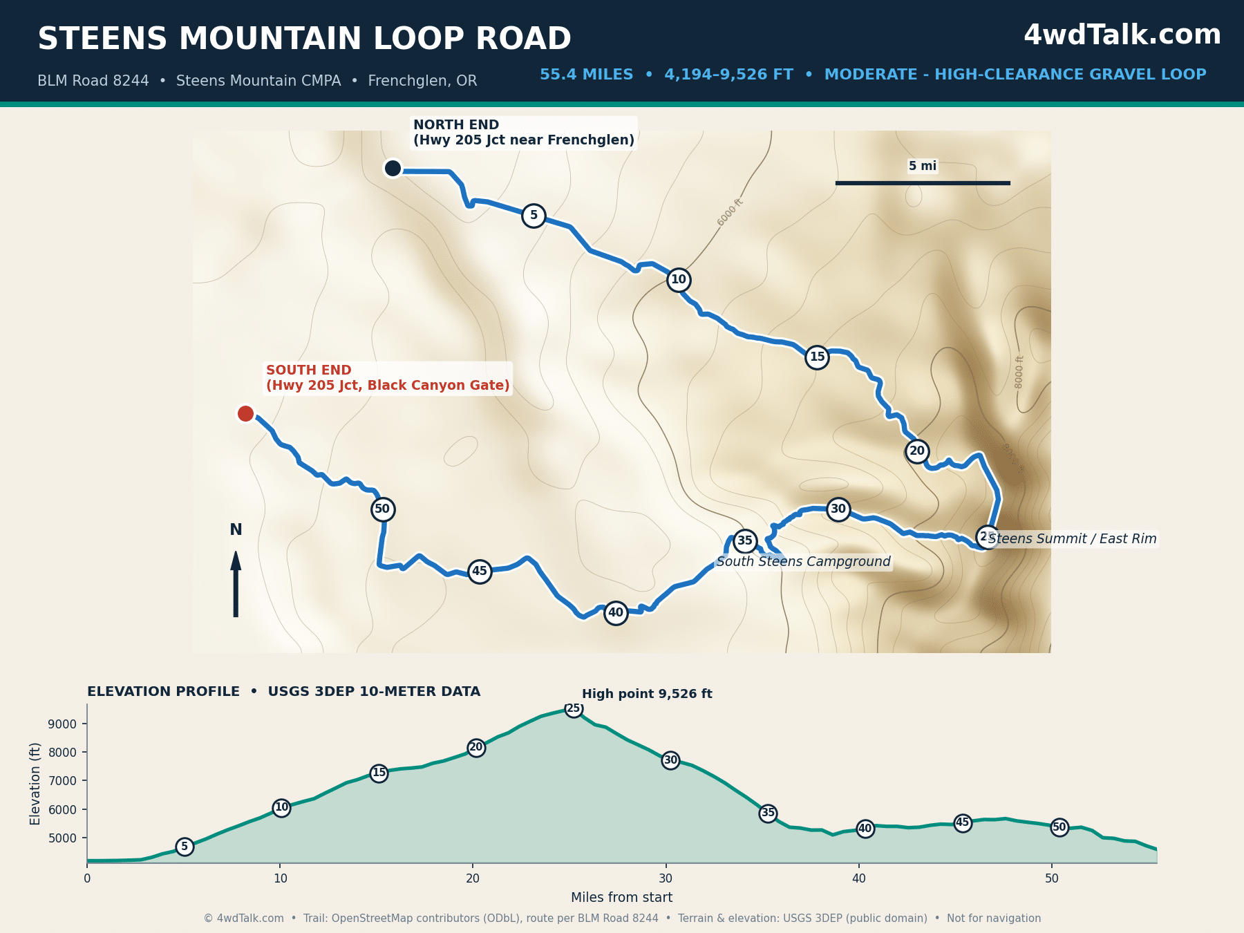
Steens Mountain holds Oregon’s highest road. Our GPS-measured trace comes in at 55.4 miles against the BLM’s published 52-mile figure. The gap traces to a winding gravel road capturing every switchback through glacial gorges like Kiger Gorge. Either way, this ranks among the longest drivable roads in the state. Notably, elevation runs from 4,194 feet near Frenchglen to 9,526 feet at the East Rim.
The BLM closes sections of the loop for snow each year. The full route typically opens only from early July through mid-October. A stock high-clearance 4×4 handles most of the grade. The steep, rocky pitch near South Steens Campground still calls for real ground clearance. Cell coverage disappears for long stretches out here. Our review of the best off-road GPS apps is worth reading before you commit to the full loop.
8. Alvord Desert Access Route
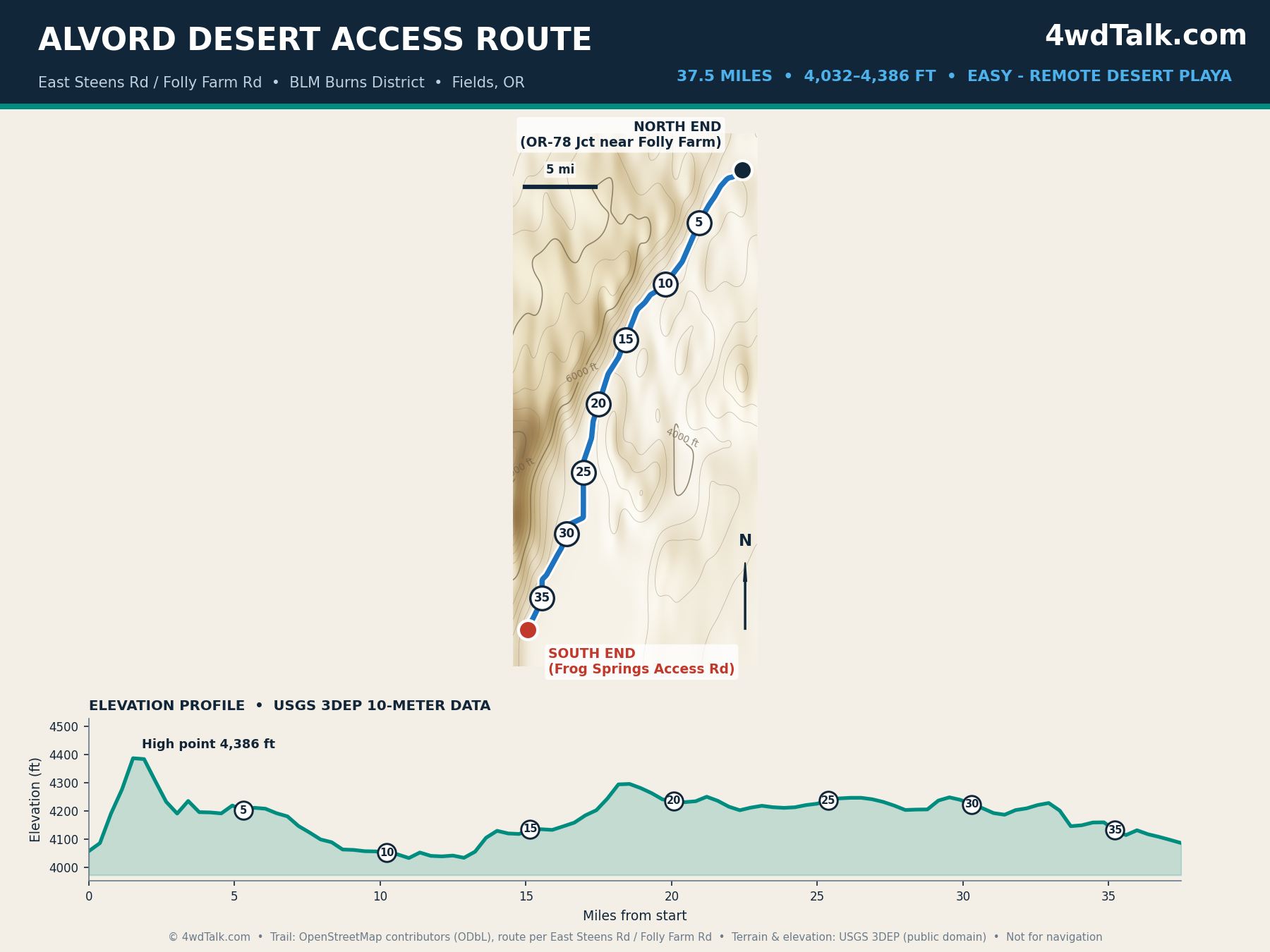
Among the trail-specific keywords in this guide, Alvord Desert draws the highest search volume by a wide margin. The flat, cracked playa on the east side of Steens Mountain earns the attention. The BLM’s directions describe roughly 40 miles south on East Steens Road, also called Folly Farm Road, to reach the Frog Springs access point onto the playa. Our GPS trace of this same segment measures 37.5 miles, a 6 percent gap, well within normal variance for a graded gravel road.
Graded gravel keeps the drive easy for most of its length. Remoteness, however, is the real hazard, since services, fuel, and cell coverage disappear for dozens of miles in every direction. Treat this as a trip needing full fuel, water, and a plan shared with someone back home. For camping, our guide to free dispersed camping in Oregon covers legal camp spots near the playa for anyone staying overnight.
9. Leslie Gulch Road
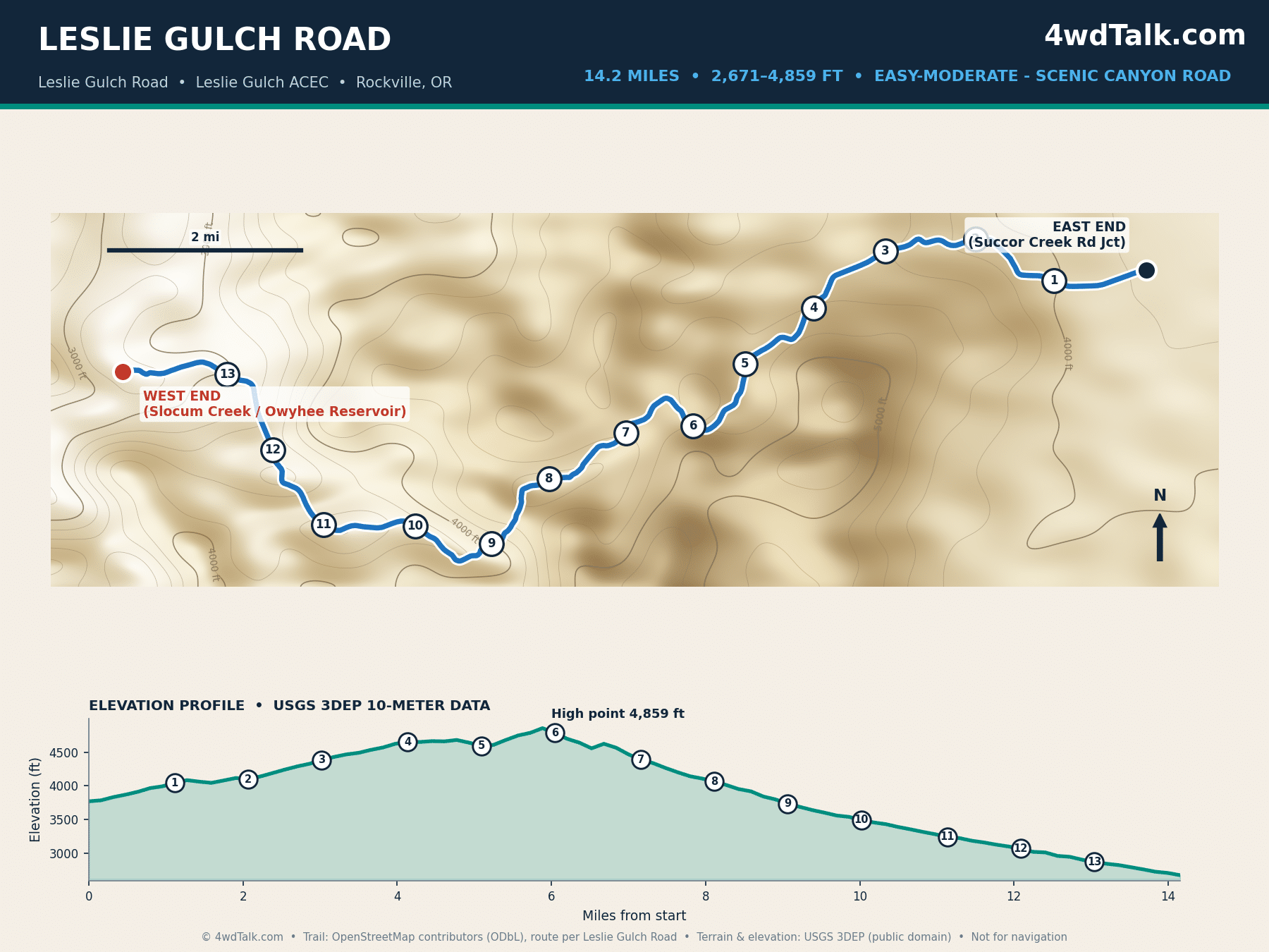
Leslie Gulch cuts through some of the most dramatic rock formations in the Owyhee region. Honeycombed tuff walls rise directly from the roadside. Our GPS trace clocks the drive at 14.2 miles from the Succor Creek Road junction down to Slocum Creek on the Owyhee Reservoir, a shade under the BLM’s rounder 15-mile estimate for the same route. Along the way, the road drops nearly 2,200 feet, so the climb back out feels longer than the drop down did.
Flash floods and wet weather turn the road impassable, even for high-clearance trucks. The BLM recommends dry-weather travel and discourages large RVs entirely. Photographers time visits for late afternoon light on the canyon walls. Boat launch access at Slocum Creek makes this a natural pairing with a reservoir trip.
10. Three Forks Road, Owyhee Canyonlands
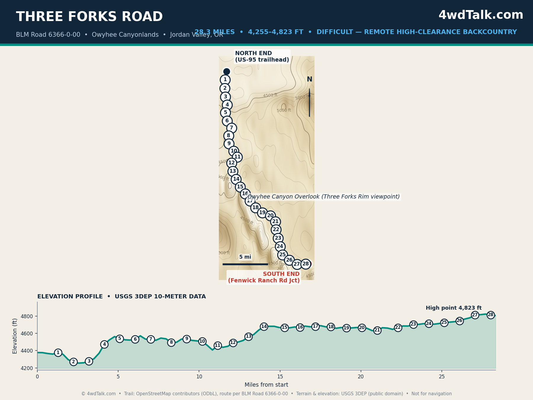
The Owyhee Canyonlands hold some of the most remote backcountry driving in Oregon. Three Forks Road is the best-documented route into them. Our map covers the full 28.3-mile road, matching published segment distances closely. It runs from a US-95 trailhead south to the Owyhee Canyon Overlook. The road itself is reasonably well-maintained gravel, not technical terrain. We rate the difficulty here as remoteness-driven instead of obstacle-driven: no cell service, few other vehicles, and long distances between fuel stops.
The overlook itself is the vehicle-accessible endpoint, since reaching the actual Three Forks river confluence below requires a hike from the rim. Plan the drive and the hike as two separate legs of one trip. Also, carry more water and fuel than the mileage alone suggests, because a breakdown out here means a long wait for help.
Sand and gravel routes like these come down to tire pressure more than anything else. Here is the air-down and air-up kit we pack for every desert trip in this guide.
Air and tire gear we pack for desert routes
MORRFlate Air Hub Automatic Tire Inflation Deflation System Controller


Northeast Oregon’s Off-Road Drive: Hat Point Road and Hells Canyon
Northeast Oregon’s corner of this guide narrows to a single route, and the narrowing is deliberate. Few maintained roads reach into the Hells Canyon backcountry, and Hat Point Road is the best-documented one open to a standard high-clearance vehicle.
11. Hat Point Road
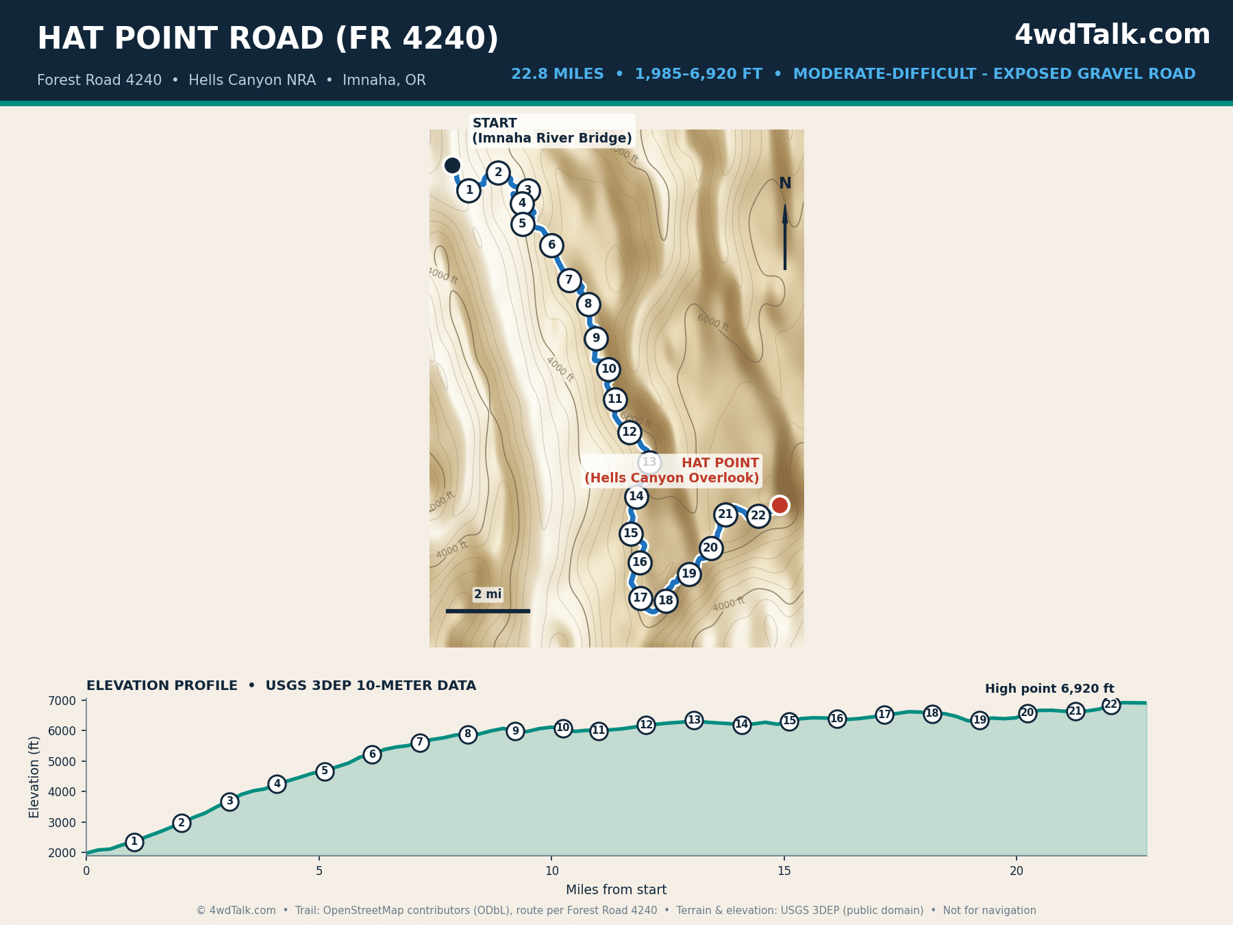
Hat Point Road climbs from the Imnaha River bridge to a rim overlook above Hells Canyon, widely cited as the deepest river gorge in North America. Published lengths for the road range from about 21 to 24 miles depending on the source. Our GPS trace, meanwhile, lands at 22.8 miles, close to several independent trip reports. The road gains almost 5,000 feet along the way. Most of the gain comes through tight switchbacks in the first two miles out of the Imnaha canyon.
Narrow tread, blind corners, and long drop-offs without guardrails define the drive. This route rewards a confident driver more than it demands a technically difficult trail. Plan a half-day round trip at minimum. Watch for oncoming traffic on the switchbacks, and check current Wallowa-Whitman National Forest conditions before you go, since the road closes with fall snow.
Pros and Cons of Wheeling Oregon
Eleven trails across three regions add up to a clear pattern. Here is what stands out on both sides of the ledger.
Pros
- Terrain ranges from sea-level coastal dunes to a 9,526-foot Steens Mountain summit
- Free access on nearly every route, since these are BLM, USFS, and state forest roads
- Long season on the coast, roughly April through October, with the Cascades summit routes opening later once snow clears
- Strong agency mapping support: USFS MVUMs, BLM directions pages, and OSM route data
- Southeast Oregon offers some of the least crowded backcountry driving in the West
- Established camping culture with legal dispersed sites near most remote routes
Cons
- Seasonal closures: Steens Mountain and McKenzie Pass both close for snow into early summer
- Southeast Oregon routes have zero cell coverage for 30 or more miles at a stretch
- Browns Camp and La Dee Flats are open riding networks, not one signed route, so navigation takes more planning
- Flash floods close canyon roads like Leslie Gulch with little notice
- Fuel and services thin out fast east of Bend, so plan every mile before you leave pavement
Which Off Road Trails in Oregon Fit Your Rig?
Stock rigs belong on Browns Camp, Sand Lake, Christmas Valley Sand Dunes, and the Alvord Desert access route. These easier trails test navigation, sand driving, and remote-trip planning instead of technical obstacles. La Dee Flats and Paulina Peak Road form the next step up. Both add steeper grades and rougher tread while still forgiving a stock drivetrain with a careful driver. A first season in Oregon covers six of these eleven trails without one vehicle modification beyond good tires and a full-size spare.
High-clearance 4x4s with skid plates open up Steens Mountain, Leslie Gulch, and Hat Point Road. Rough tread and long, exposed drops matter more than raw horsepower on these three. Three Forks Road in the Owyhee Canyonlands stands apart from the rest of this list. The road grade itself is easy, but the remoteness demands full-size fuel and water reserves and a satellite communicator. Match the trail to the least-prepared vehicle and driver in your group, not the most capable one.
Gear mentioned in this guide
Final Verdict
Start where your vehicle and experience honestly place you. For a first Oregon trail, Browns Camp teaches navigation with bailouts and cell service close by. The Alvord Desert route delivers the biggest scenery for the least mechanical risk, if you plan around its remoteness. Drivers chasing Oregon’s toughest driving should build toward Steens Mountain and Three Forks Road.
The real trade-offs here are season and distance, not difficulty. Steens Mountain and McKenzie Pass both sit closed under snow for roughly half the year, which compresses the driving window into summer and early fall. Southeast Oregon’s remoteness is the main risk, so pair any Alvord or Owyhee trip with a satellite communicator and a shared trip plan.
Value is hard to beat, since every route costs nothing beyond fuel, aside from a few modest day-use fees. Oregon’s real advantage is variety: coastal dunes, volcanic summits, and high desert canyons in a single state.
Whatever off road trails in Oregon you run first, air down properly and log your line choices before a canyon road or a desert crossing. Pair the eleven maps above with official agency maps and current conditions before you leave pavement. If California is next, our guide to the best off-road trails in California covers the sibling routes south of the border.
Browns Camp on a Saturday morning or a full weekend on the Steens loop, either way the MORRFlate TenSix gets all four tires back to street pressure before your coffee cools.
MORRFlate TenSix Off Road Air Compressor, 12 Volt Heavy Duty Tire Inflator
FAST 10.6 CFM INFLATION: Air up a set of 35″ tires in under 5 minutes when used with the MORRFlate multi-tire inflation and deflation kits.
- 10.6 CFM dual-cylinder output
- Fills four 35-inch tires in about 5 minutes
- Inflates and deflates four tires at once with the kit
- Overkill for a single daily driver staying on pavement
Frequently Asked Questions
Where is Steens Mountain Loop Road?
Steens Mountain Loop Road climbs the east side of the Steens Mountain range in southeast Oregon’s Harney County. The BLM manages it under the Steens Mountain Cooperative Management and Protection Area. The most common access point sits near Frenchglen on Highway 205, roughly a 62-mile drive southeast of Burns.
How long is the Alvord Desert access route?
Our GPS-measured route along East Steens Road, also called Folly Farm Road, covers 37.5 miles. It runs from the OR-78 junction near Folly Farm south to the Frog Springs access point on the playa. The BLM’s own directions describe the same segment as approximately 40 miles, a gap consistent with the difference between graded-road distance and straight-line estimates.
Is Hat Point Road open in winter?
No. Hat Point Road closes with the first significant fall snow. It typically reopens in late spring or early summer once Forest Service crews clear the route. Check current Wallowa-Whitman National Forest conditions before planning a trip, since exact opening dates shift year to year with snowpack.
Do you need a permit to off-road in Oregon?
Most routes in this guide sit on BLM or Forest Service land open to any street-legal, registered vehicle without a special permit. Oregon requires an ATV permit sticker for OHVs used on designated OHV trails and dunes, including plated vehicles, such as the interior networks at Browns Camp and La Dee Flats. Confirm current land-agency rules before a trip, since seasonal closures and fee areas change.
What is the highest road in Oregon?
Steens Mountain Loop Road holds this title, climbing to roughly 9,500 feet along the East Rim near Steens Summit. Our elevation profile measures a peak of 9,526 feet on the mapped route, closely matching the BLM’s published figures for the summit area.
When is the best season for Oregon’s high desert trails?
Southeast Oregon routes like Steens Mountain, the Alvord Desert, and the Owyhee Canyonlands run best from early July through mid-October. Spring snowmelt clears the higher elevations by then, and fall storms have not yet arrived. Browns Camp on the coast holds a longer season, generally April through October, while McKenzie Pass stays gated until snow clears, typically opening in late June and running through October.