


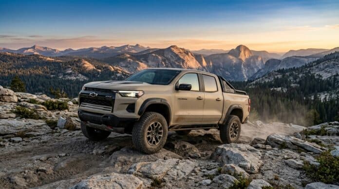
Quick Verdict: The best off road trails in California range from granite rock crawling above Lake Tahoe to 10,000-foot Sierra crest routes. In addition, a 127-mile desert crossing of the Mojave National Preserve rounds out the list. For most drivers, Big Bear’s Gold Mountain is the smartest first trail. In contrast, the Rubicon and Johnson Valley’s Sledgehammer sit at the expert end. Every trail below includes a custom topo map with mile markers and a USGS elevation profile.
Last updated: July 2026 | 14 min read
In This Guide
- How We Picked the Best Off Road Trails in California
- All 11 Trails at a Glance
- Sierra Granite: Tahoe to Kaiser Pass
- Desert and Southern Sierra Routes
- Southern California: Big Bear to Borrego
- Pros and Cons of Wheeling California
- Which Off Road Trails in California Fit Your Rig?
- Final Verdict
- Frequently Asked Questions
How We Picked the Best Off Road Trails in California
This guide maps 11 of the best off road trails in California, from the Oregon-facing Sierra to the Mexican border deserts. Above all, no other state packs this much terrain variety into one trip list. We weighed terrain, scenery, published difficulty, and legal access on every candidate before cutting the list to 11. Our team has driven the Big Bear trails, Monache Meadows, and the Anza-Borrego washes firsthand. As a result, the Southern California picks reflect seat time as well as research.
Each entry below includes one of 11 custom trail maps built from public USGS elevation data and USFS route records. A pretty graphic is worthless if the numbers are wrong. For this reason, these California off-road trails all get GPS-measured mileage, mile markers, and an elevation profile in feet. Where our measured mileage disagrees with an agency figure, we say so in the trail notes instead of hiding the gap.
Difficulty ratings follow the source agency or the consensus of published guides. In practice, a “moderate” here means a careful driver in a stock high-clearance 4×4 finishes the route. An “extreme” rating means lockers, 35-inch tires, and rocker protection as the realistic minimum. New to rating systems? Our guide on how to navigate off-road trails like a pro explains the symbols before you attempt anything above intermediate.
All 11 Trails at a Glance
| Trail | Mapped Miles | Difficulty | Region |
|---|---|---|---|
| Rubicon Trail | 17.0 | Extreme | Lake Tahoe |
| Fordyce Creek Trail | 11.7 | Extreme | Tahoe NF |
| Dusy-Ershim Trail | 28.0 | Extreme, multi-day | Sierra NF |
| Monache Meadows | 9.1 | Moderate, remote | Kern Plateau |
| Titus Canyon Road | 26.2 | Easy-moderate, one-way | Death Valley |
| Mojave Road | 127.1 | Moderate, multi-day | Mojave Preserve |
| Gold Mountain Trail | 4.5 | Moderate-difficult | Big Bear |
| John Bull Trail | 5.0 | Difficult | Big Bear |
| Sledgehammer Trail | 1.1 | Extreme | Johnson Valley |
| Fish Creek to Sandstone Canyon | 13.9 | Easy-moderate | Anza-Borrego |
| Diablo Dropoff | 2.3 | Moderate, one-way | Anza-Borrego |
Sierra Granite: Tahoe to Kaiser Pass
1. Rubicon Trail
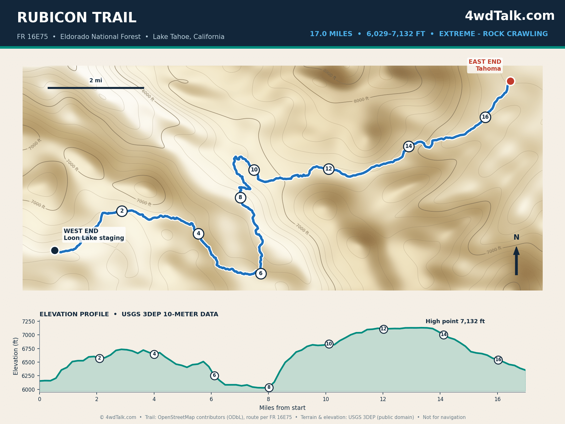
The Rubicon is the most famous rock-crawling route in the world. It earns the reputation with 17 GPS-measured miles between Loon Lake staging and Tahoma on the lake’s west shore. Agency figures range from 12 to 22 miles depending on which endpoints they count. El Dorado County publishes an official trail map and a free Avenza version. Pre-run planning is easier here than on any other extreme trail in the state. Landmark obstacles include the Gatekeeper, Little Sluice, Big Sluice, and Cadillac Hill, and elevation runs from 6,029 to 7,132 feet.
Plan on lockers front and rear, 35-inch tires, and a full day minimum; groups camping at Rubicon Springs often take two or three. Snow typically closes the trail into early summer, so check county trail status before driving up. The Rubicon’s granite ledges are no place to learn your kit is incomplete. Review the 4×4 recovery gear you need in your kit before attempting any trail in this tier.
2. Fordyce Creek Trail
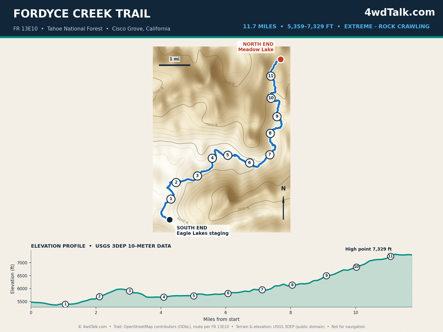
Fordyce runs 11.7 miles from the Eagle Lakes staging area to Meadow Lake in Tahoe National Forest. However, USFS paperwork lists it at 11.9 miles. The trail climbs nearly 2,000 feet through a series of famous winch hills. Also, seasonal releases from Fordyce Creek’s dam swing the water crossings from mild to intimidating. Most groups treat it as a two-day trip with a night at Meadow Lake.
Difficulty sits in the same tier as the Rubicon, although Fordyce trades open granite for ledgy climbs and deeper water. Check Tahoe National Forest conditions first, because crossing depth is the gatekeeper here.
3. Dusy-Ershim Trail
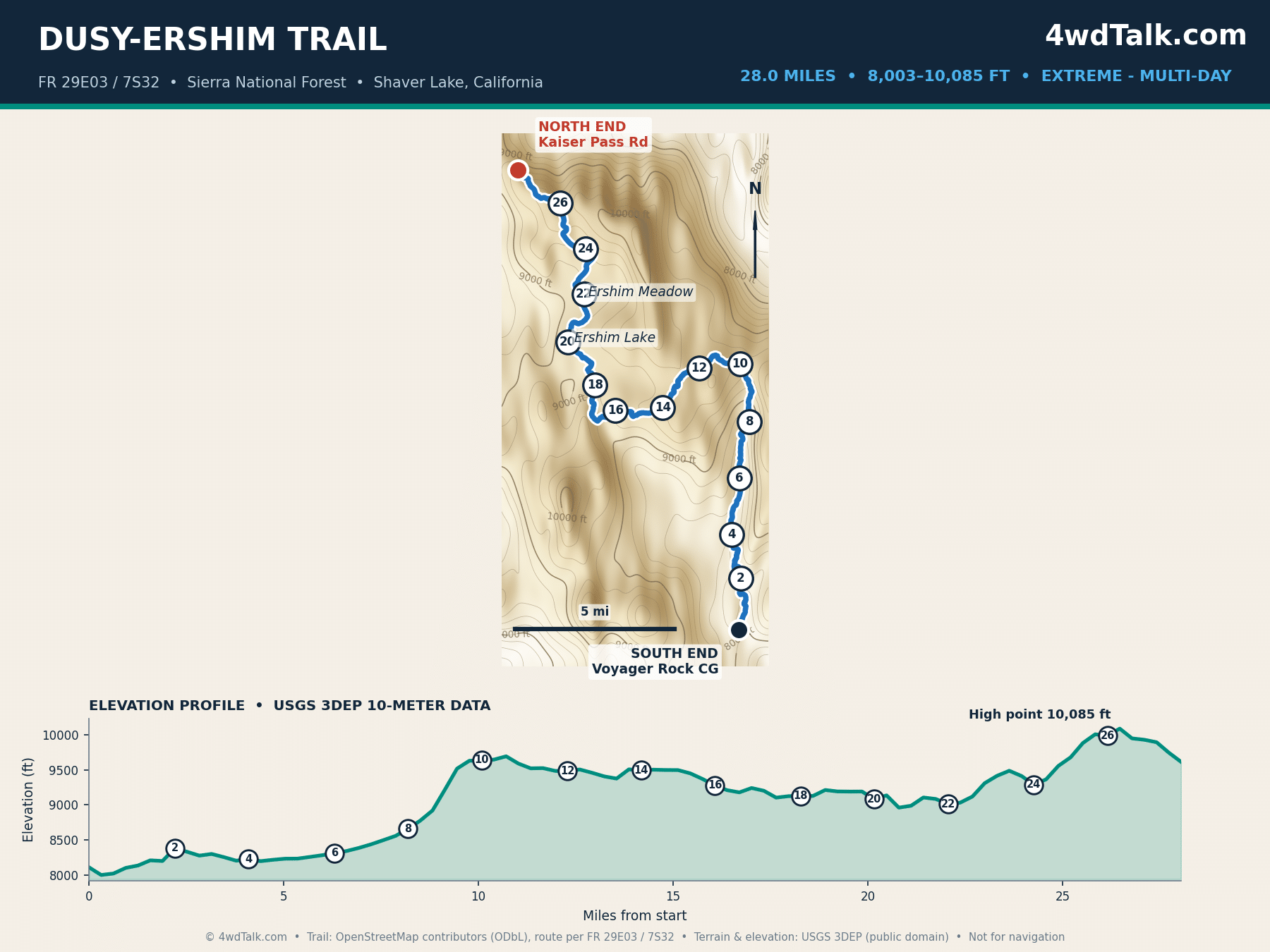
Twenty-eight miles of granite separate Courtright Reservoir from the Kaiser Pass area. Moreover, our Dusy-Ershim profile tops out at 10,085 feet along the way. The Forest Service quotes about 33 miles including connector roads; either way, plan two to three days of first-gear crawling. High camps at Ershim Lake and Ershim Meadow rank among the best trail campsites in the state.
This is the most committing route on our list after the Mojave Road. Bailouts are few, and the season runs midsummer to early fall. Therefore, run it with at least two rigs and full recovery equipment.
Every trail in this guide starts the same way: airing down. A dual-cylinder compressor like the MORRFlate TenSix refills four 35s in minutes at the end of the day. Instead of waiting on a pump, spend your daylight on obstacles.

MORRFlate TenSix 12 Volt Air Compressor Heavy Duty, 10.6 CFM 150 PSI Dual Cylinder Portable Off-Road Tire Inflator for Jeep Truck RV 4x4 Overlanding, 4 Tire Inflation Deflation, 4FT Steel Hose
FAST 10.6 CFM INFLATION: Air up a set of 35″ tires in under 5 minutes when used with the MORRFlate multi-tire inflation and deflation kits.
- 10.6 CFM dual-cylinder output
- Fills four 35-inch tires in about 5 minutes
- Inflates and deflates four tires at once with the kit
- Overkill for a single daily driver staying on pavement
Desert and Southern Sierra Routes
4. Monache Meadows
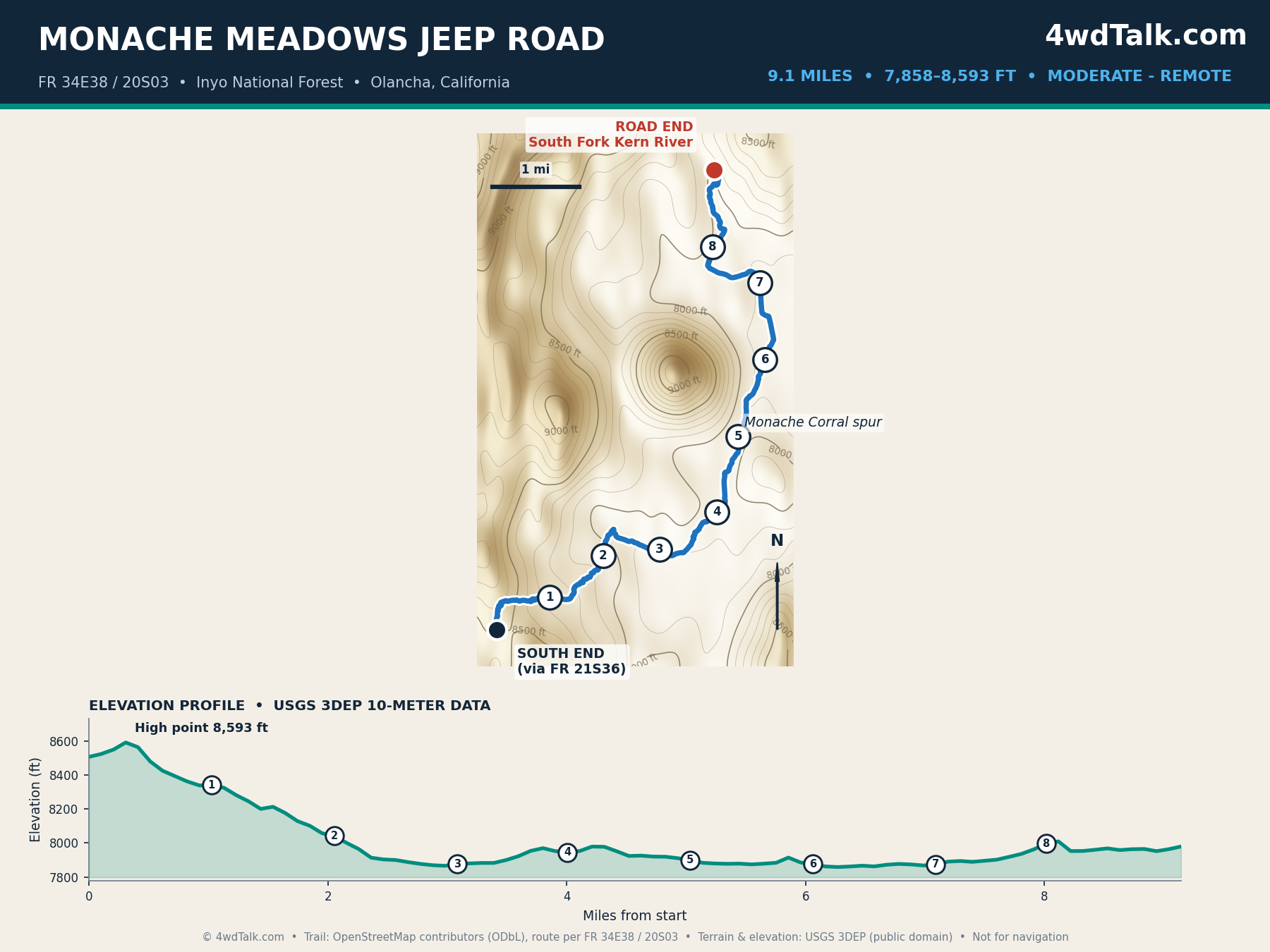
Monache Meadows is one of the largest high-elevation meadows in the Sierra. The 9.1-mile jeep road into it stays near 8,000 feet the whole way. We have driven this one ourselves. Notably, its payoff is a high basin with South Fork Kern River crossings, brook trout water, and views of Olancha Peak. The rocky descent from the FR 21S36 side demands high clearance, while the meadow roads themselves stay mellow.
Remoteness is the real hazard here; cell coverage is zero and help is hours away. Download offline maps in one of the best off-road GPS apps before leaving Sherman Pass Road.
5. Titus Canyon Road
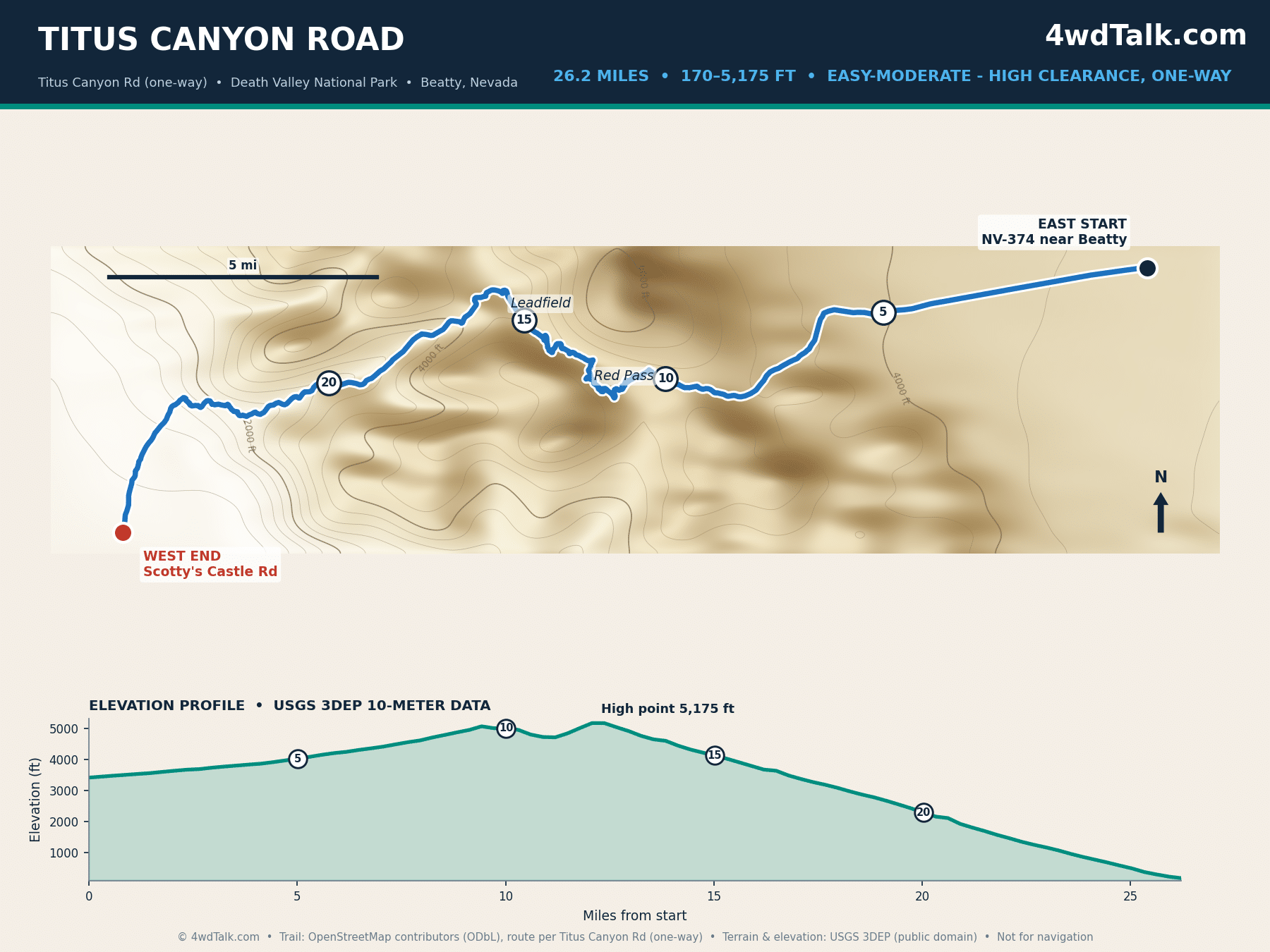
Titus Canyon is Death Valley’s signature backcountry drive. The 26.2 one-way miles start on NV-374 near Beatty and climb over 5,175-foot Red Pass. From there the road drops past the Leadfield ghost town into narrows tight enough for one vehicle. The National Park Service rates it high-clearance rather than technical. As a result, a stock 4×4 or AWD truck handles it in dry conditions. Grades are steep, however, and the one-way rule means commitment once you drop off Red Pass.
Go in fall through spring, since summer canyon temperatures are dangerous. The park closes the road after storms, so check current conditions before the long drive around to the Nevada-side start.
6. Mojave Road
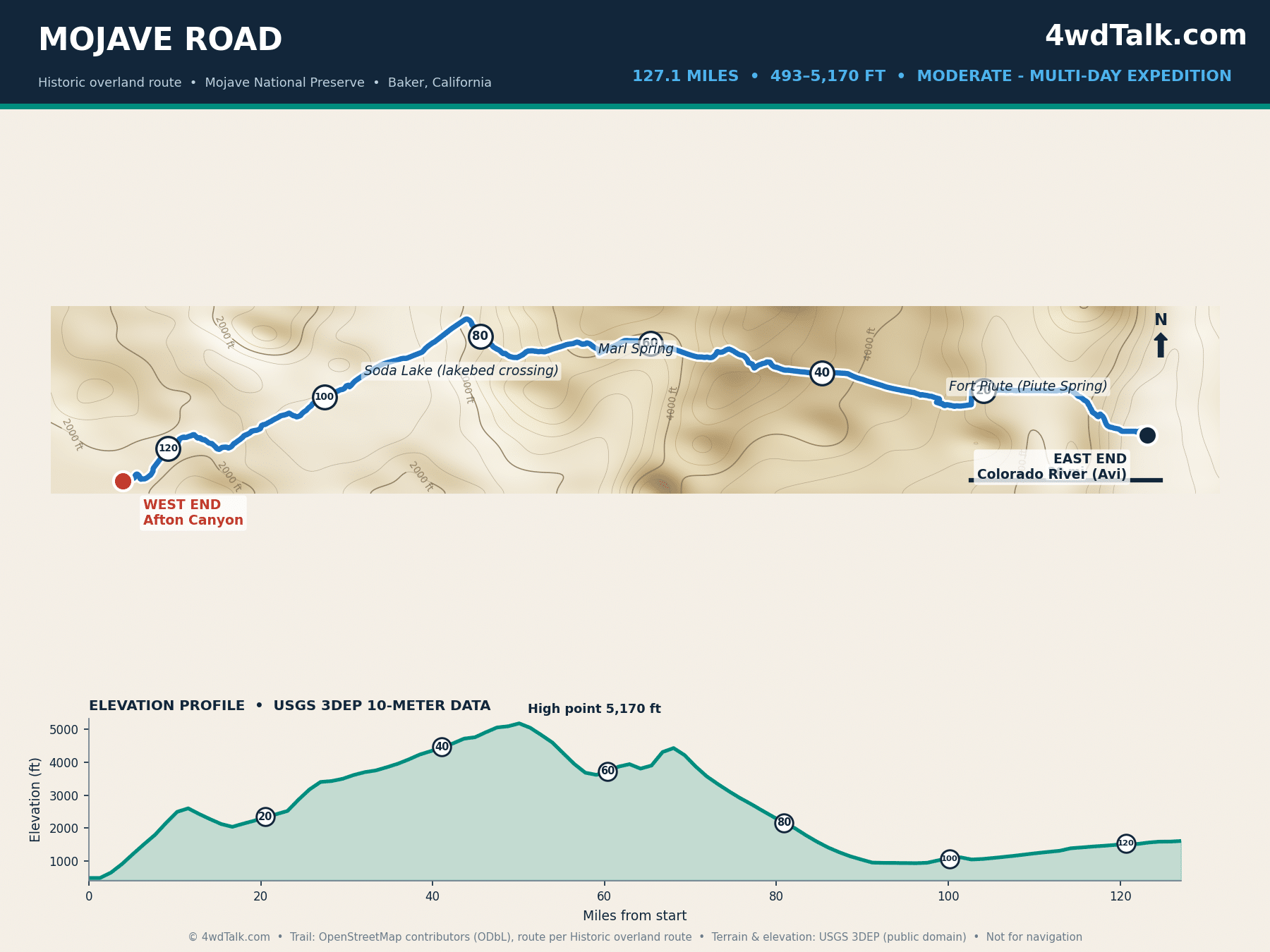
The Mojave Road is California’s classic overland route. Specifically, it follows a Native American trade corridor and later wagon road for 127 mapped miles, Colorado River to Afton Canyon. The National Park Service counts roughly 150 miles for the full historic route. Its western reach continues past our mapped end toward Camp Cady on the Mojave River. Along the way you pass Fort Piute, Marl Springs, and the Soda Lake lakebed. Elevation swings from 493 to 5,170 feet, and most groups take three days.
Deep sand sections swallow momentum, so air down early. A good set of tire deflators for overlanding turns the job into a two-minute stop. Skip Soda Lake after rain, because the crust turns to axle-deep mud. Finally, historic route etiquette is simple: travel east to west, sign the mailbox register, and pack out everything.
Sand routes like the Mojave Road come down to tire pressure, so here is the air-down and air-up kit we run on every desert trip.
Air and tire gear we pack for desert routes

MORRFlate Air Hub Digital Air Controller Universal AutoMagic Tire I…



MORRFlate Ultimate 4x4 Tire Plug Kit Heavy Duty Professional Off-Ro…
Southern California: Big Bear to Borrego
7. Gold Mountain Trail
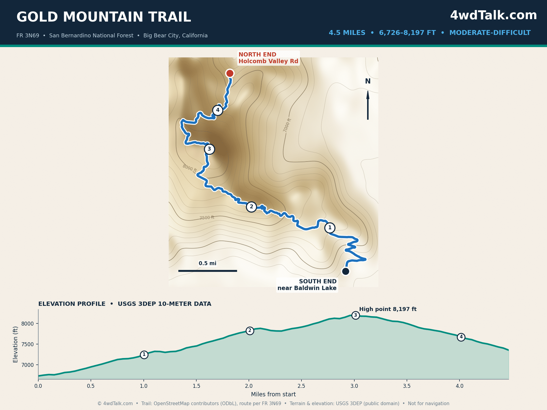
Gold Mountain climbs 4.5 miles from Baldwin Lake to Holcomb Valley Road, topping out at 8,197 feet. Especially up top, the lake views beat anything else in this guide. The lower rock gardens give beginners a real taste of line choice, yet nearly every obstacle has a bypass. In our experience it is the best first “real” trail in Southern California, hard enough to teach, forgiving enough to finish.
A stock 4×4 with skid plates and a patient spotter completes it in two to three hours. Afterward, John Bull sits directly across the valley when you want the next step up.
8. John Bull Trail
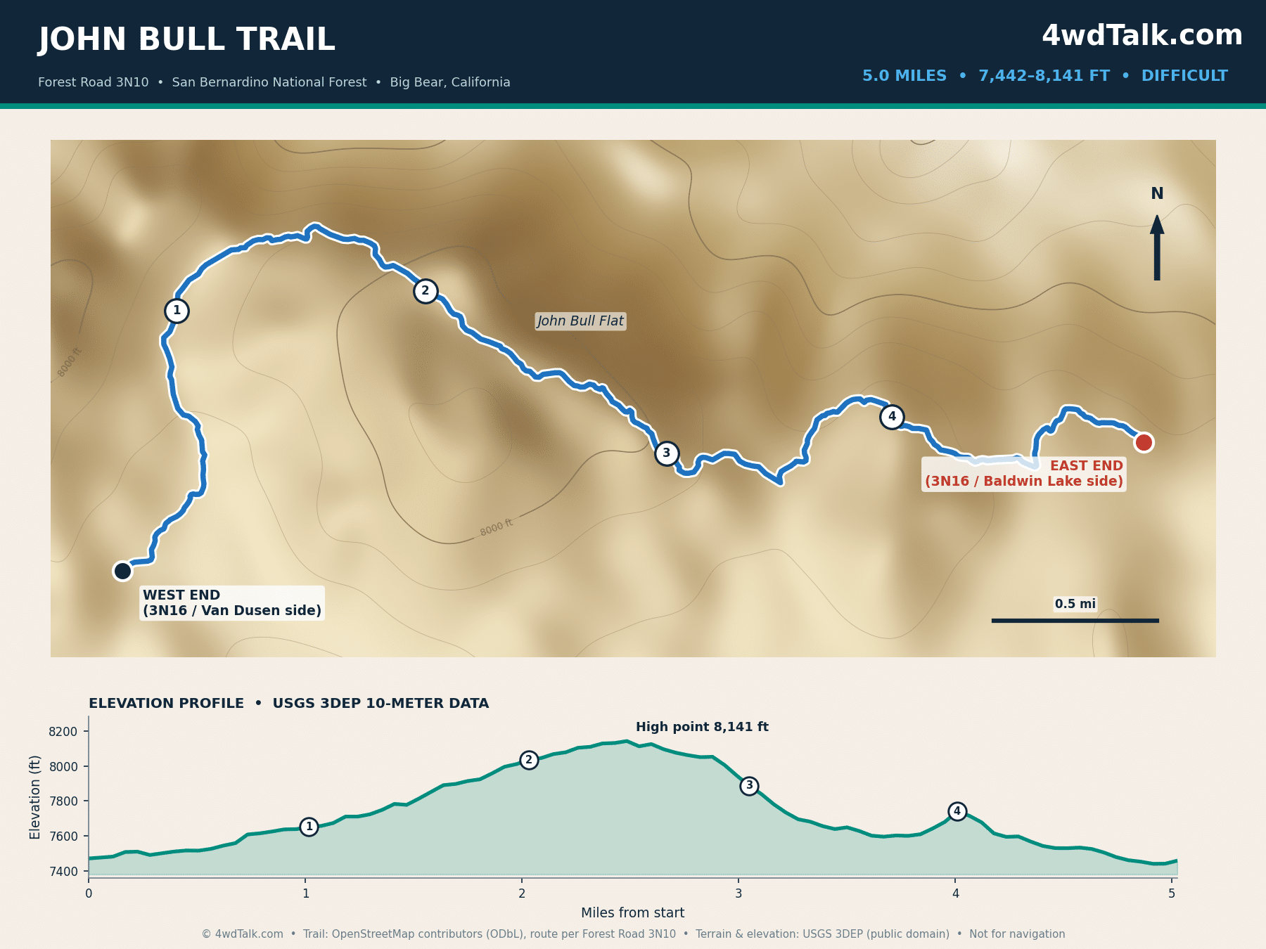
Wheelers widely call John Bull the hardest trail in the Big Bear area. Our team has run these mountains enough to agree. The rock-crawling core covers roughly 3 miles of boulder fields between two junctions with 3N16. Meanwhile, our map shows the full 5-mile Forest Road 3N10, including the mellower eastern flats near Baldwin Lake. Elevation stays between 7,442 and 8,141 feet, which keeps summer temperatures reasonable.
Expect body damage risk in full-size rigs, and skip it entirely in stock vehicles. Gold Mountain, one entry back, is the smarter warmup when John Bull looks like too much.
9. Sledgehammer Trail, Johnson Valley
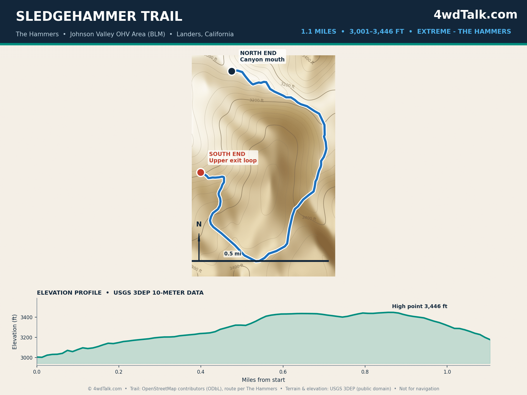
King of the Hammers made this canyon famous. The trail sits inside Johnson Valley, the largest OHV area in the country. On ledges like these, the race earned its name. Our mapped line covers 1.1 miles of boulder stacks and waterfall ledges, climbing about 450 feet. However, published figures range from a half mile for the canyon core to a full mile with the exit loop. Buggies and purpose-built crawlers are the normal traffic here.
Treat mileage as meaningless on the Hammers trails; hours per mile is the honest metric. The surrounding desert and Means Dry Lake give stock rigs plenty to do while built trucks work the canyons.
10. Fish Creek Wash to Sandstone Canyon
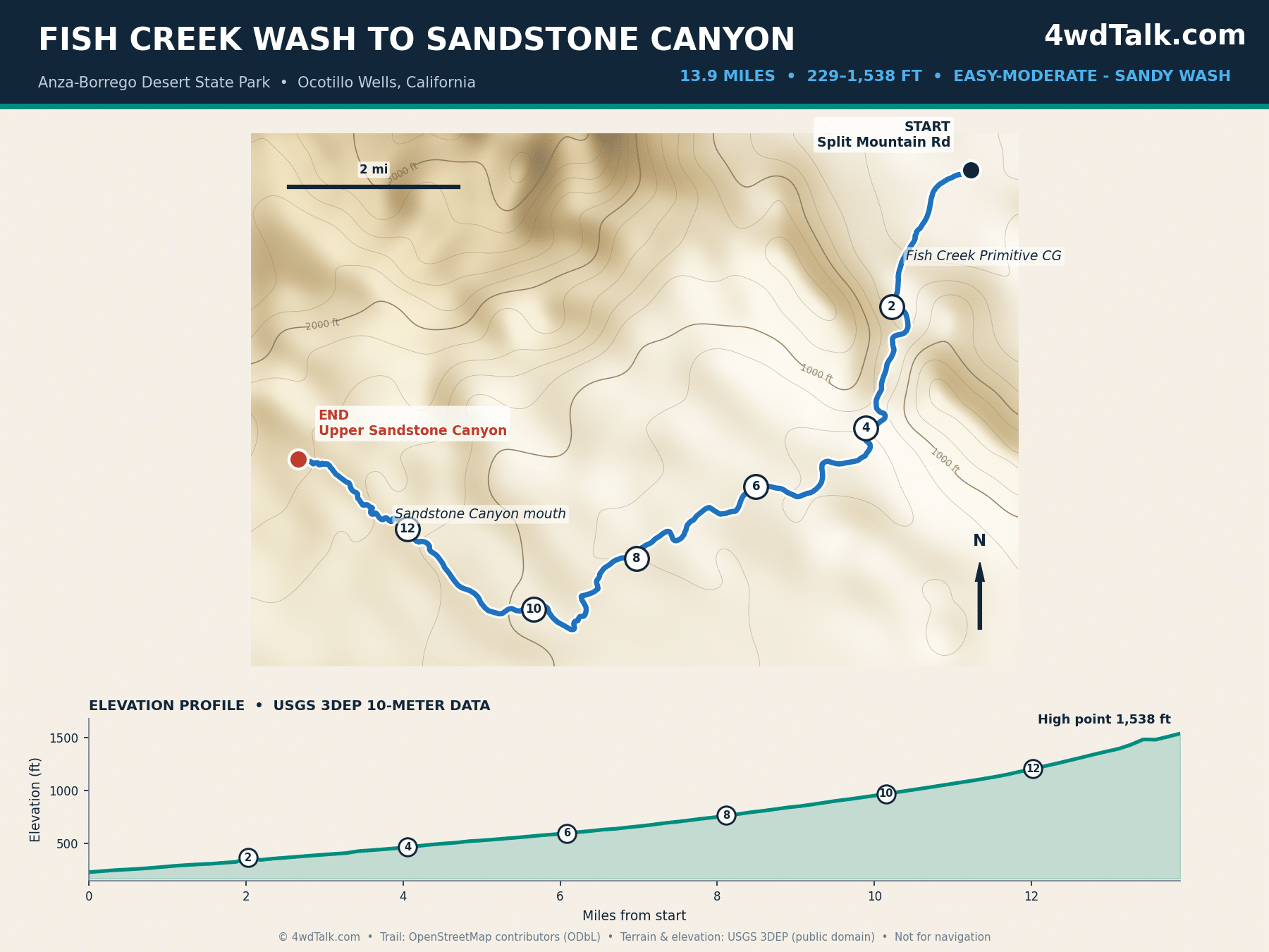
Fish Creek Wash runs 13.9 miles from Split Mountain Road into the tightening walls of Sandstone Canyon. It is also the best beginner-friendly desert run in Anza-Borrego. The route passes through the Split Mountain gorge, where the canyon walls expose a textbook anticline. From there it climbs gradually, 229 to 1,538 feet. After several trips through these washes, we rate the scenery-to-difficulty ratio the highest on this list.
Anza-Borrego is a state park, so every vehicle must be street legal and stay on designated routes. Sand stays soft in stretches; airing down to mid-teens PSI keeps momentum without drama.
11. Diablo Dropoff
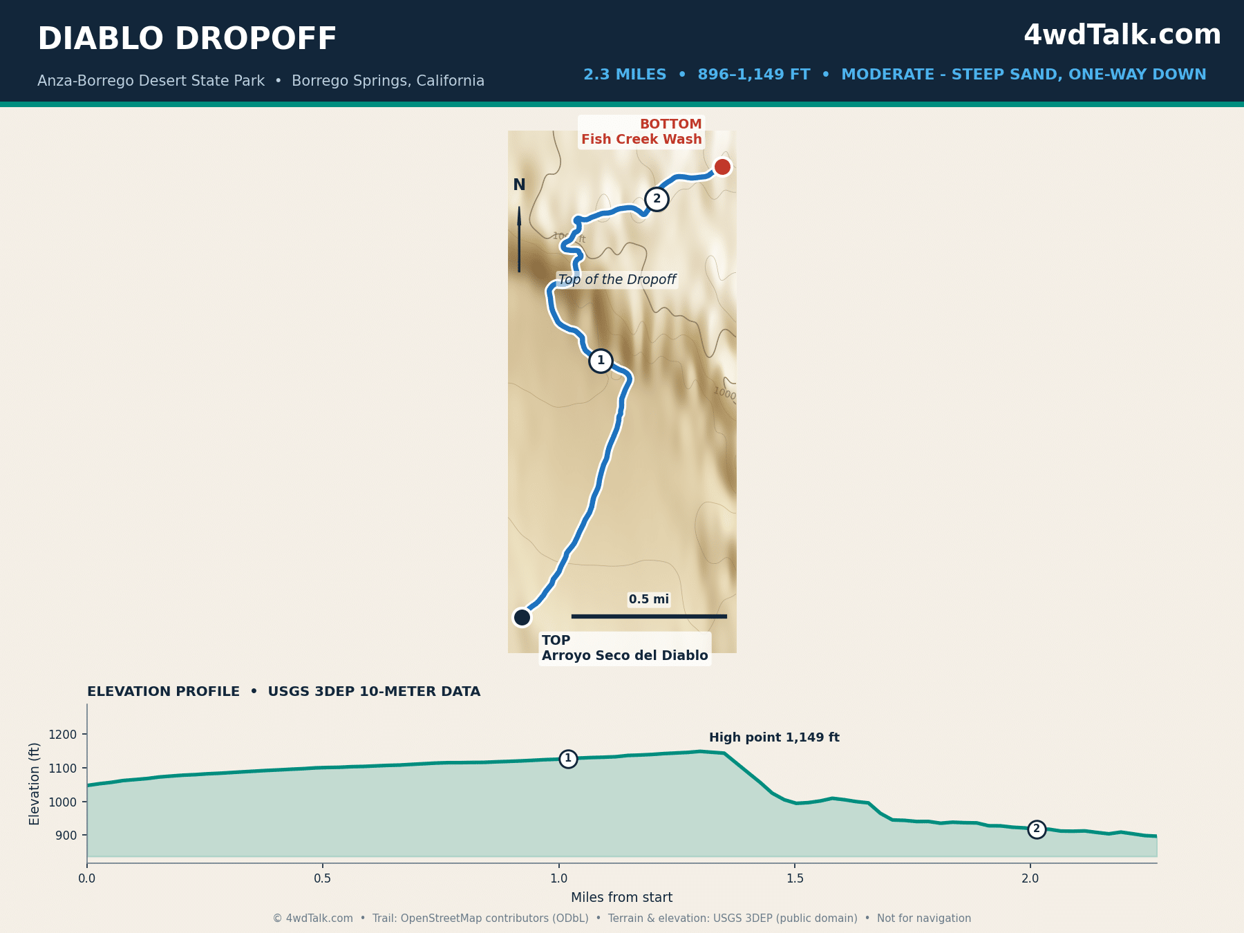
Diablo Dropoff is the adrenaline connector of Anza-Borrego. Its 2.3 miles fall from Arroyo Seco del Diablo down a pair of steep sand chutes into Fish Creek Wash. The descent is one-way for good reason, since climbing back up the soft grade is unrealistic for most vehicles. Pair it with Fish Creek and Sandstone Canyon for a full desert day.
Loose sand punishes hesitation, so pick your line at the top and keep steady throttle. Recovery traffic is rare out here; carrying traction boards is cheap insurance for the sandy floor below.
Pros and Cons of Wheeling California
Pros
- Terrain ranges from 229-foot desert washes to 10,085-foot Sierra crest granite
- Year-round wheeling: desert season runs October to April, Sierra season June to October
- The Rubicon and Johnson Valley are benchmark 4×4 trails within two hours of major cities
- Strong agency mapping support: county Avenza maps, USFS MVUMs, and NPS backcountry maps
- Free access on most routes; Johnson Valley and the national forest trails cost nothing
- Established camp culture with legal dispersed sites on the multi-day routes
Cons
- Seasonal closures: Rubicon snow lingers into early summer, desert routes are unsafe in 110°F months
- State park rules exclude non-street-legal rigs from Anza-Borrego’s 500+ miles of routes
- Popular weekends bring trail traffic, especially Big Bear and the Rubicon
- Remote routes have zero cell coverage for 50+ miles at a stretch
- Storm damage closes desert canyons with little notice, so plans need backups
Which Off Road Trails in California Fit Your Rig?
Stock rigs belong on Titus Canyon, Fish Creek to Sandstone Canyon, Monache Meadows, and the Mojave Road. Instead of boulders, these easier 4×4 trails test navigation, sand driving, and remoteness. Gold Mountain and Diablo Dropoff form the next step, adding rock gardens and steep loose descents while still forgiving stock drivetrains with careful driving. A driver’s first season in California covers six of these eleven trails without a single modification beyond good tires. Notably, the beginner ladder lives in the south and the desert. Northern California drivers build up at OHV parks like Hollister Hills or Prairie City before graduating to the Sierra granite.
Built rigs with front and rear lockers, 35-inch or larger tires, and armor open up John Bull. Next come the Rubicon, Fordyce, and the Dusy-Ershim. Sledgehammer stands alone; even among California off-road trails with extreme ratings, the Hammers canyons assume tube work, one-ton axles, and a working winch. Match the trail to the weakest vehicle in your group, not the strongest. The trail does not care which rig started the day looking built.
Gear mentioned in this guide
MORRFlate Air Hub Digital Air Controller Universal AutoMagic Tire I…
MORRFlate Ultimate 4x4 Tire Plug Kit Heavy Duty Professional Off-Ro…
Final Verdict
Start where your vehicle and experience honestly place you. For a first California trail, Gold Mountain teaches rock work with bailouts everywhere. Meanwhile, Fish Creek to Sandstone Canyon delivers the biggest scenery for the least risk. Drivers chasing a life-list achievement should build toward the Rubicon. Similarly, overlanders should block three days for the Mojave Road before the desert season ends in spring.
The trade-offs are seasonal windows and crowd timing more than trail quality. Big Bear fills up on summer weekends, so run Gold Mountain and John Bull midweek when possible. The Sierra extreme-trail season compresses into a June-to-October window, which makes early-fall weekdays the sweet spot for Fordyce and the Dusy-Ershim.
Value is hard to beat, since ten of the eleven routes cost nothing beyond fuel. Death Valley’s park entrance fee covers Titus Canyon. Year-round wheeling is the state’s quiet advantage; when the Sierra closes, the desert opens.
Whatever you run first among these off road trails in California, log your line choices and air down properly. Finally, leave every gate and register the way you found it. The eleven trail maps above are planning references. Pair them with official agency maps and current conditions before you leave pavement.
Your first run might be Gold Mountain or a three-day Mojave crossing. Either way, the MORRFlate TenSix gets all four tires back to street pressure before your coffee cools.
MORRFlate TenSix 12 Volt Air Compressor Heavy Duty, 10.6 CFM 150 PSI Dual Cylinder Portable Off-Road Tire Inflator for Jeep Truck RV 4x4 Overlanding, 4 Tire Inflation Deflation, 4FT Steel Hose
FAST 10.6 CFM INFLATION: Air up a set of 35″ tires in under 5 minutes when used with the MORRFlate multi-tire inflation and deflation kits.
- 10.6 CFM dual-cylinder output
- Fills four 35-inch tires in about 5 minutes
- Inflates and deflates four tires at once with the kit
- Overkill for a single daily driver staying on pavement
Frequently Asked Questions
Where is the Rubicon Trail?
The Rubicon Trail crosses the Sierra Nevada west of Lake Tahoe. It runs from the Loon Lake staging area in Eldorado National Forest east to Tahoma on the lake’s west shore. Most traffic stages from the Loon Lake side, reached from US 50 via Ice House Road east of Sacramento.
How long is the Rubicon Trail?
Our GPS-measured route covers 17.0 miles from Loon Lake staging to the Tahoma side. The most technical granite concentrates in the middle miles around the Sluices and Rubicon Springs. Agency figures vary between 12 and 22 miles depending on which endpoints and connectors each source counts. Therefore, treat published lengths as approximations.
Where are you allowed to go off-roading in California?
California concentrates its legal OHV trails on National Forest routes shown on Motor Vehicle Use Maps. Riders also have BLM open areas like Johnson Valley, state OHV parks, and designated state park routes such as Anza-Borrego’s washes. Cross-country travel off designated routes is illegal statewide. Also, each land agency publishes free maps showing exactly which routes are open.
What is the hardest OHV trail in the US?
Most experts point to the Johnson Valley Hammers trails, including Sledgehammer, as the hardest regularly driven routes in the country. Race teams build six-figure vehicles around these canyons for King of the Hammers. Even the obstacles on the “easy” Hammers lines exceed the Rubicon’s hardest.
Do you need a green sticker for California OHV trails?
Street-legal vehicles with current registration run every trail in this guide without extra permits. Non-street-legal rigs need a California Green Sticker OHV registration on forest and BLM routes; the state no longer issues Red Stickers, and legacy stickers now carry year-round validity. Anza-Borrego Desert State Park excludes non-street-legal vehicles entirely.
When is the best season for these trails?
Desert routes including the Mojave Road, Titus Canyon, and Anza-Borrego run best October through April. Conversely, high Sierra trails open as snow melts, typically June through October. Big Bear’s trails split the difference with a long April-to-November season at 7,000+ feet.