




Quick Verdict: The best off road trails in Arizona run from Sedona slickrock and Grand Canyon rim roads to a 124-mile desert crossing near the Mexican border. For most drivers, Sedona’s Broken Arrow is the smartest first trail. In contrast, Charouleau Gap near Tucson and the Table Mesa rock lines sit at the expert end. Overlanders should point their rigs at El Camino del Diablo. Every trail below includes a custom topo map with mile markers and a USGS elevation profile.
Last updated: July 2026 | 14 min read
In This Guide
- How We Picked the Best Off Road Trails in Arizona
- All 11 Trails at a Glance
- Northern Arizona: Sedona Red Rock to the Grand Canyon
- Central Arizona: Bradshaws and the Sonoran Desert
- Southern Arizona: Sky Islands to the Border Desert
- Pros and Cons of Wheeling Arizona
- Which Off Road Trails in Arizona Fit Your Rig?
- Final Verdict
- Frequently Asked Questions
How We Picked the Best Off Road Trails in Arizona
This guide maps 11 of the best off road trails in Arizona, from the red rock of Sedona to the border deserts below Ajo. Above all, no other state pairs ponderosa pine forest and 120-mile desert crossings this closely. We weighed terrain, scenery, published difficulty, and legal access on every candidate before cutting the list to 11. Our team has driven the Sedona trails firsthand, so the Broken Arrow and Schnebly Hill picks reflect seat time as well as research.
Each entry below includes one of 11 custom trail maps built from public USGS elevation data and agency route records. A clean graphic is worthless if the numbers are wrong. For this reason, these Arizona off-road trails all get GPS-measured mileage, mile markers, and an elevation profile in feet. Where our measured mileage disagrees with an agency or app figure, we say so in the trail notes instead of hiding the gap.
Difficulty ratings follow the source agency or the consensus of published guides. In practice, a “moderate” here means a careful driver in a stock high-clearance 4×4 finishes the route. A “difficult” rating means lockers, 33-inch or larger tires, and skid protection as the realistic minimum. New to rating systems? Our guide on how to navigate off-road trails like a pro explains the symbols before you attempt anything above intermediate.
All 11 Trails at a Glance
| Trail | Mapped Miles | Difficulty | Region |
|---|---|---|---|
| Broken Arrow Trail | 3.3 round-trip | Moderate | Sedona |
| Schnebly Hill Road | 11.0 | Easy-moderate, scenic | Sedona |
| Cinder Hills OHV Area | 11.6 loop | Easy | Flagstaff |
| Toroweap Road | 59.4 | Moderate, remote | Grand Canyon |
| Backway to Crown King | 25.3 | Moderate-difficult | Bradshaw Mtns |
| Four Peaks Road | 27.1 | Moderate, high clearance | Tonto NF |
| Box Canyon | 10.3 | Easy-moderate | Florence |
| Table Mesa | 4.2 | Rock-crawling area | New River |
| Charouleau Gap | 18.2 | Difficult | Tucson |
| Chiva Falls | 2.4 each way | Moderate | Tucson |
| El Camino del Diablo | 123.8 | Moderate, multi-day | Ajo to Yuma |
Before the trail-by-trail breakdown, here is the air-up and tire kit we run on every Arizona trip.
| Product | TOP PICK MORRFlate TenSix Off Road Air Compressor MORRFlate TenSix Off Road Air Compressor |  MORRFlate Quad 4 Tire Inflation System Hose Kit Only MORRFlate Quad 4 Tire Inflation System Hose Kit Only |  MORRFlate Air Hub Automatic Tire Inflation Deflation System Controller MORRFlate Air Hub Automatic Tire Inflation Deflation System Controller |  MORRFlate Ultimate Tire Plug Kit Heavy Duty MORRFlate Ultimate Tire Plug Kit Heavy Duty |
| Price | $230.00 as of Oct 22, 2:01 am | $249.99 as of Oct 22, 3:48 am | $39.99 as of Oct 22, 6:08 am | |
| Check Price → | Check Price → | Check Price → | Check Price → |
Northern Arizona: Sedona Red Rock to the Grand Canyon
1. Broken Arrow Trail
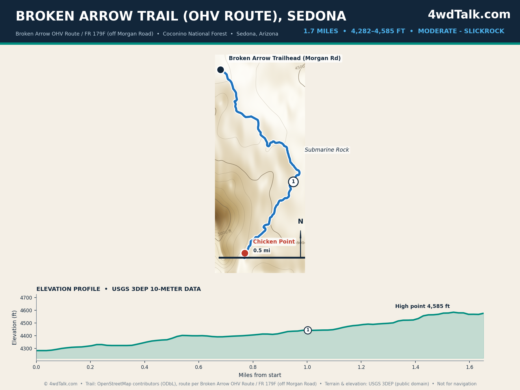
Broken Arrow is the most popular 4×4 trail in Sedona, and we have driven it ourselves. The OHV route covers about 3.3 round-trip miles from the Morgan Road trailhead to Chicken Point. So our map traces the 1.7-mile run out to the point. Note that our figure follows the driven jeep track, not the separate hiking path that shares the name. Landmarks include Devil’s Dining Room, Submarine Rock, and the slickrock bowl at Chicken Point. The Devil’s Staircase, the steep slickrock step down toward the point, is where you slow down and let a spotter place your tires. Elevation stays between 4,282 and 4,585 feet.
A stock 4×4 with skid plates and a patient spotter finishes it in two to three hours. Traffic is heavy on weekends, since guided pink jeeps share the trail. Go on a weekday morning for a cleaner run. The slickrock steps reward tire placement over horsepower, which makes this a smart first “real” trail.
2. Schnebly Hill Road
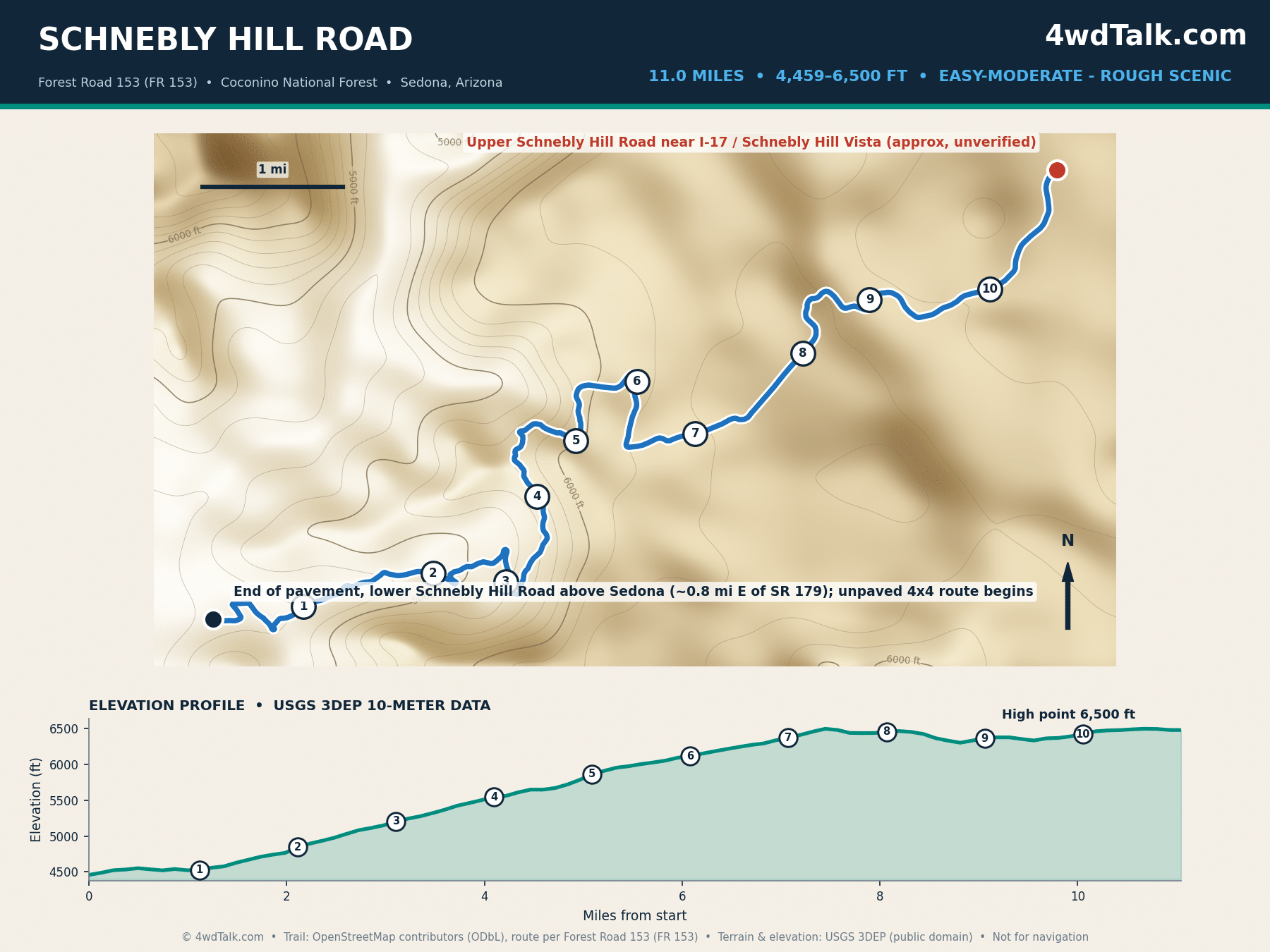
Schnebly Hill Road is the scenic climb out of Sedona, and it is another route we have driven. The unpaved 4×4 portion of Forest Road 153 runs 11.0 miles from the end of pavement up to the vista near Interstate 17. The Forest Service lists 6.3 miles, but that number is the hiking trail. Still, the drivable road matches the 11 to 12 miles that trail apps report. It climbs roughly 2,000 feet past red rock overlooks of Munds Mountain and the Mogollon Rim. The roughest going sits in the middle switchbacks below the vista, where washboard and embedded ledges earn the road its reputation.
The road is rough rather than technical, so a stock high-clearance 4×4 or capable AWD handles it in dry weather. Washboard and embedded rock rattle the low sections. Drive it uphill from Sedona for the best views over your shoulder, then air down for comfort on the return.
3. Cinder Hills OHV Area
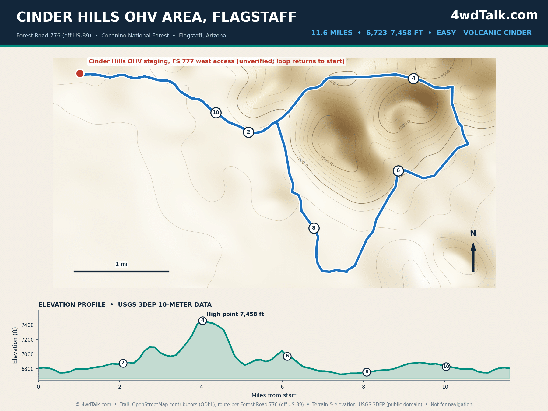
Cinder Hills is a 13,500-acre volcanic playground northeast of Flagstaff. Because it is an open OHV area rather than a single route, our map shows a representative 11.6-mile loop assembled from the main double-track. Trail apps rate the full network near 14 miles, and the extra mileage lives in the informal cinder cone climbs that never make a base map. Elevation runs from 6,723 to 7,458 feet, so summer temperatures stay mild.
Loose black cinder behaves like sand, so momentum matters more than clearance. The area sits at high elevation, which means snow can close it in winter. Non-street-legal rigs need a current Arizona OHV decal here, since this is a designated riding area on the Coconino National Forest.
4. Toroweap Road
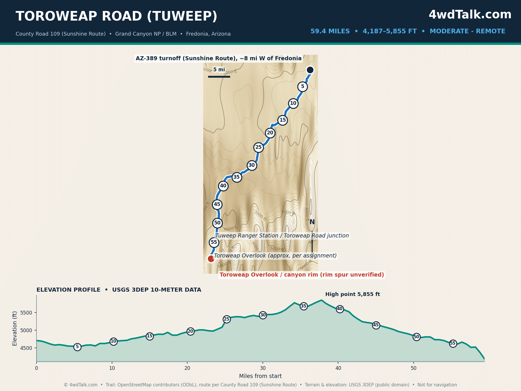
Toroweap, also spelled Tuweep, delivers the wildest overlook in the Grand Canyon. The Sunshine Route (County Road 109) runs 59.4 mapped miles from Arizona 389 south to the canyon rim. That is close to the 61 miles the Park Service quotes. The payoff is a 3,000-foot vertical drop straight to the Colorado River with no railing. Along the way you cross open range near Mount Trumbull at 4,187 to 5,855 feet.
The route is graded dirt for most of its length, then rougher near the rim where high clearance earns its keep. Remoteness is the real hazard; there is no water, no fuel, and no cell service for the entire distance. Check the National Park Service Tuweep page for road status, and carry recovery gear plus a full-size spare before you commit.
A dual-cylinder compressor like the MORRFlate TenSix refills four 33s or 35s in minutes at the end of a trail day, so you spend your daylight wheeling instead of waiting on a slow pump.
MORRFlate TenSix Off Road Air Compressor, 12 Volt Heavy Duty Tire Inflator
FAST 10.6 CFM INFLATION: Air up a set of 35″ tires in under 5 minutes when used with the MORRFlate multi-tire inflation and deflation kits.
- 10.6 CFM dual-cylinder output
- Fills four 35-inch tires in about 5 minutes
- Inflates and deflates four tires at once with the kit
- Overkill for a single daily driver staying on pavement
Central Arizona: Bradshaws and the Sonoran Desert
5. Backway to Crown King
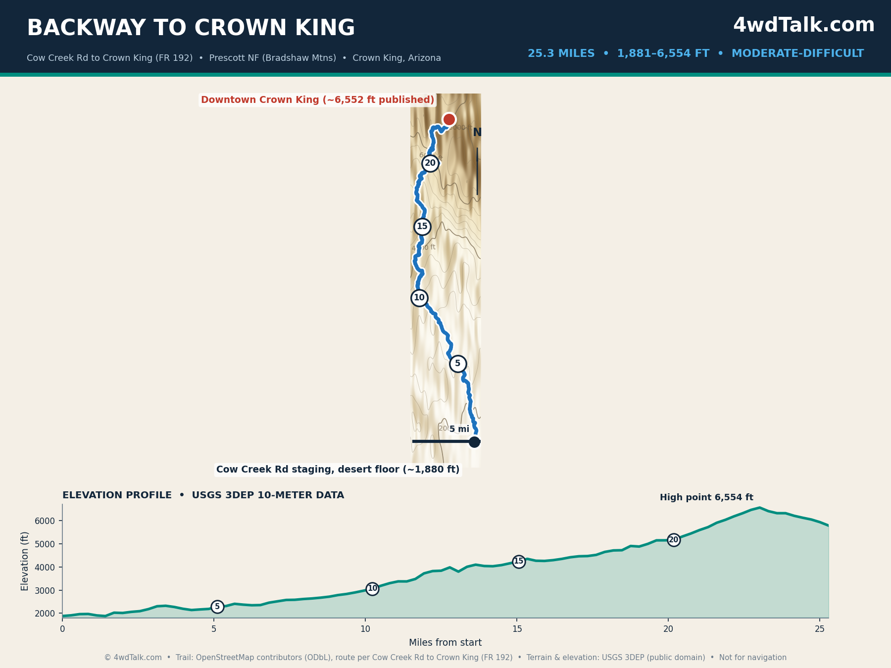
The Backway to Crown King is a Jeep Badge of Honor trail and the best full-day climb near Phoenix. Our map covers 25.3 miles from the Cow Creek Road staging area up to the old mining town of Crown King. Published figures range from 26 miles one-way to 34 miles, depending on where each source starts counting. So we mark the low desert approach that our map does not include. The route climbs almost 4,700 feet, from 1,881 feet of saguaro desert to 6,554 feet of ponderosa pine.
Most of the trail is moderate, with rocky sections and a few optional obstacles near the old mines. A stock 4×4 with good tires and low range makes it, though the upper switchbacks reward patience. Plan three to five hours and start early, because there is no quick bail-out once you begin the climb.
6. Four Peaks Road
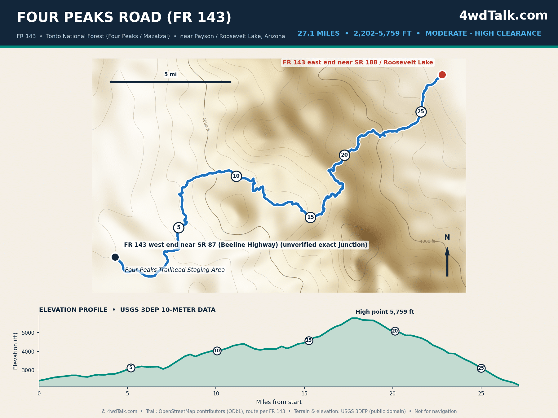
Four Peaks Road (Forest Road 143) is a scenic traverse of the Mazatzal Mountains east of Phoenix. Our map runs 27.1 miles from State Route 87, the Beeline Highway, across to State Route 188 near Roosevelt Lake. The route tops out near 5,759 feet under the granite spires of Four Peaks, with long views over the Sonoran Desert below. Elevation swings from 2,202 to 5,759 feet across the crossing.
This is a high-clearance road rather than a technical trail, so a stock 4×4 or capable SUV handles it in dry conditions. Shelf sections drop off steeply, and the surface turns greasy after rain. Fall through spring is the sweet spot, since the low desert ends bake in summer.
7. Box Canyon
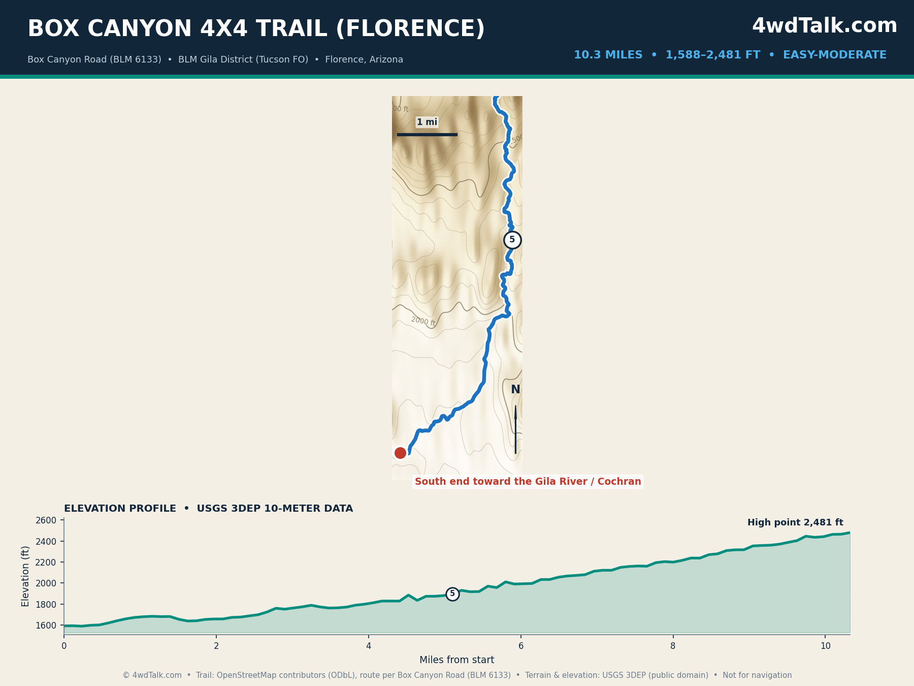
Box Canyon near Florence is one of the most driven desert trails in central Arizona. Our map covers the 10.3-mile canyon core of North Box Canyon Road. Trail apps list the point-to-point route at 16 to 20 miles. But those figures include the long approach roads to the trailhead, which is why our canyon-only measurement runs shorter. The route follows a wash between rock walls, climbing gently from 1,588 to 2,481 feet.
Most of the canyon is easy, though one rocky step near the middle needs care or a stack of rocks for lower rigs. A stock high-clearance 4×4 completes it in two to three hours. Skip it after heavy rain, because desert washes flash flood without warning.
8. Table Mesa
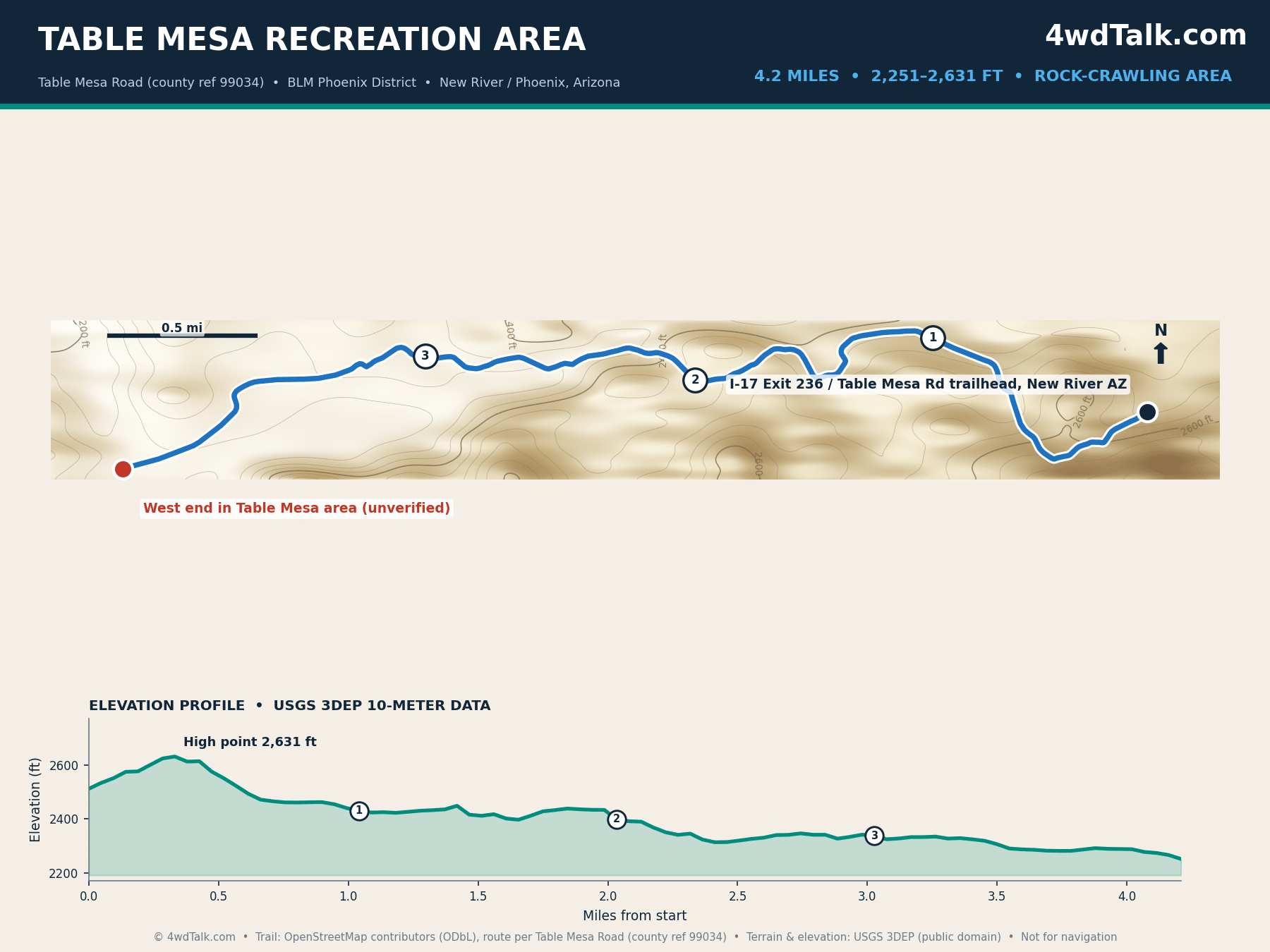
Table Mesa is the rock-crawling hub north of Phoenix, reached from the Table Mesa Road exit off Interstate 17. Our map shows the 4.2-mile main road corridor that threads the area, because the famous hard lines here are short, named obstacles rather than through-routes. Terminator, Predator, and Boulder Pile branch off this spine, and they range from moderate ledges to buggy-only walls. Elevation barely moves, from 2,251 to 2,631 feet.
Treat mileage as meaningless on the hard lines; hours per obstacle is the honest metric. The graded corridor itself suits any high-clearance rig, so beginners can explore while built trucks work the ledges. Part of the area closes from January to mid-June for bald eagle nesting, so check current access before you tow out.
Desert routes like Box Canyon and the border crossings come down to tire pressure, so here is the air-down and air-up kit we run on every sand trip.
Air and tire gear we pack for desert routes
MORRFlate Air Hub Automatic Tire Inflation Deflation System Controller
Southern Arizona: Sky Islands to the Border Desert
9. Charouleau Gap
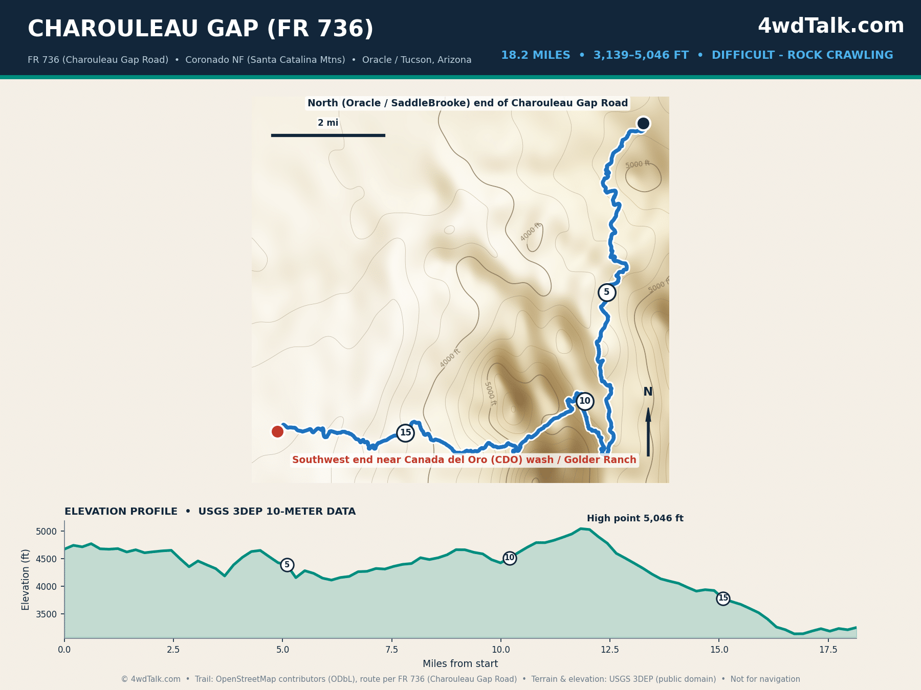
Charouleau Gap is Tucson’s benchmark hard trail. Forest Road 736 runs 18.2 miles from the Oracle and SaddleBrooke side, up and over Samaniego Ridge, down to the Cañada del Oro wash. Our measurement matches the 18.1 miles that trail apps report. The route crosses the granite flanks of the Santa Catalina Mountains, climbing from 3,139 feet to a high point near 5,046 feet.
The Forest Service rates this a rough, rocky four-wheel-drive road, and wheelers rate the gap itself difficult. Lockers, 33-inch or larger tires, and skid protection are the realistic minimum. Plan a full day, since the technical ledges near the gap slow the whole group. Carry recovery gear and run it with a second rig.
10. Chiva Falls
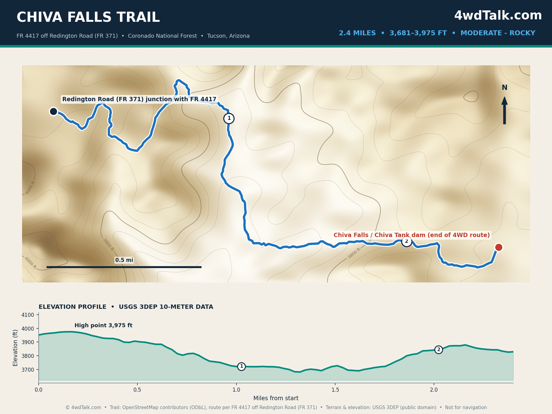
Chiva Falls pairs a short rocky drive with a seasonal waterfall east of Tucson. Our map follows the 4×4 route 2.4 miles each way from Redington Road down Forest Road 4417 to the Chiva Tank dam. Longer figures you see online, near 8 miles, are round-trip hiking distances measured from farther out. The drive itself climbs and drops between 3,681 and 3,975 feet.
The road is rocky and rated moderate, with grade-2 ledges and loose surface. A stock high-clearance 4×4 reaches the road end, then a short walk drops to the pour-over below. The falls run best after winter and monsoon rain, so time your trip to the weather. Non-street-legal rigs need an Arizona OHV decal on this Coronado National Forest route.
11. El Camino del Diablo
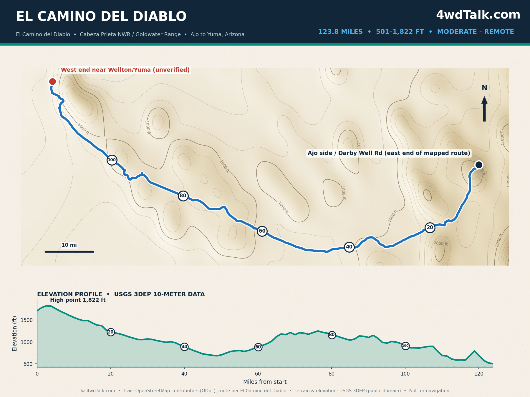
El Camino del Diablo, the Devil’s Highway, is Arizona’s classic overland route. Our map follows 123.8 mapped miles from Ajo west toward Yuma, close to the 130 miles most guides cite for the full historic road. The route crosses Cabeza Prieta National Wildlife Refuge and the Barry Goldwater Range, past Tinajas Altas and Tule Well. Elevation stays low, from 501 to 1,822 feet, across some of the most remote desert in the country.
The driving is moderate, deep sand in stretches and washboard between, so air down early. A good set of tire deflators for overlanding turns the job into a two-minute stop. This is a permit route: you need a Cabeza Prieta refuge permit and a Goldwater Range range permit, and you must sign a hold-harmless agreement. Most groups take two to three days, carry all their water, and travel with a second vehicle.
Pros and Cons of Wheeling Arizona
Pros
- Terrain ranges from 500-foot border desert to 7,400-foot pine forest near Flagstaff
- Year-round wheeling: desert season runs October to April, high country runs April to November
- Sedona, Crown King, and El Camino del Diablo are bucket-list trails within a short drive of major cities
- Strong app and agency mapping: onX and Gaia, plus USFS, NPS, and BLM route data
- Free access on most routes; the national forest and BLM trails cost nothing
- Distinct scenery: red rock, volcanic cinder, Sky Island granite, and open Sonoran desert
Cons
- Summer desert heat is dangerous, with lower routes unsafe above 105°F
- El Camino del Diablo needs refuge and range permits plus a signed hold-harmless form
- Sedona weekends bring heavy trail traffic and guided jeep tours
- Remote routes like Toroweap have zero cell service for 60 miles at a stretch
- Monsoon storms flash flood desert washes with little warning
- Non-street-legal rigs need a current Arizona OHV decal on forest and BLM routes
Which Off Road Trails in Arizona Fit Your Rig?
Stock rigs belong on Schnebly Hill Road, Cinder Hills, Four Peaks Road, Box Canyon, and the deep-sand crossing of El Camino del Diablo. Instead of boulders, these easier 4×4 trails test navigation, sand driving, and remoteness. Broken Arrow and the Backway to Crown King form the next step, adding slickrock steps and long rocky climbs while still forgiving stock drivetrains with careful driving. A driver’s first season in Arizona covers seven of these eleven trails without a single modification beyond good tires.
Built rigs with front and rear lockers, 33-inch or larger tires, and armor open up Charouleau Gap and the hard lines at Table Mesa. Toroweap and El Camino del Diablo demand preparation rather than articulation, so their challenge is water, fuel, and distance, not obstacles. Match the trail to the weakest vehicle in your group, not the strongest. The desert does not care which rig started the day looking built.
Every trail in this guide runs better with the recovery basics on board. Review the 4×4 recovery gear you need in your kit and download offline maps in one of the best off-road GPS apps before you leave pavement.
Here again is the air-down, air-up, and repair kit those desert days call for.
Gear mentioned in this guide
MORRFlate Air Hub Automatic Tire Inflation Deflation System Controller
Final Verdict
Start where your vehicle and experience honestly place you. For a first Arizona trail, Broken Arrow teaches slickrock line choice with a spotter watching. Meanwhile, Box Canyon and Four Peaks Road deliver big desert scenery for low risk. Drivers chasing a hard day should build toward Charouleau Gap or the Table Mesa ledges. Overlanders should block three days for El Camino del Diablo and sort their permits well ahead.
The trade-offs are seasonal windows and crowd timing more than trail quality. Sedona fills up on weekends, so run Broken Arrow and Schnebly Hill midweek when possible. The desert routes near the border compress into an October-to-April window, which makes winter the sweet spot for El Camino del Diablo and Box Canyon.
Value is hard to beat, since all eleven routes cost nothing beyond fuel and the occasional permit. Year-round wheeling is the state’s quiet advantage; when the Bradshaws and Flagstaff cool off, the southern desert opens up. Whatever you run first among these off road trails in Arizona, log your line choices and air down properly. Leave every gate and register the way you found it. The eleven trail maps above are planning references. Pair them with official agency maps and current conditions before you leave pavement.
Your first run might be Broken Arrow or a three-day desert crossing. Either way, the MORRFlate TenSix gets all four tires back to street pressure before your coffee cools.
MORRFlate TenSix Off Road Air Compressor, 12 Volt Heavy Duty Tire Inflator
FAST 10.6 CFM INFLATION: Air up a set of 35″ tires in under 5 minutes when used with the MORRFlate multi-tire inflation and deflation kits.
- 10.6 CFM dual-cylinder output
- Fills four 35-inch tires in about 5 minutes
- Inflates and deflates four tires at once with the kit
- Overkill for a single daily driver staying on pavement
Frequently Asked Questions
Where is Broken Arrow Trail?
Broken Arrow Trail sits immediately south of downtown Sedona in the Coconino National Forest. The OHV route starts from the Morgan Road trailhead and climbs to Chicken Point over about 1.7 miles each way. Most drivers reach it from State Route 179 through the Broken Arrow neighborhood.
How long is El Camino del Diablo?
Our GPS-measured route covers 123.8 miles from the Ajo side west toward Yuma. Most published guides cite roughly 130 miles for the full historic road, since the exact endpoints vary by trip. The route crosses Cabeza Prieta National Wildlife Refuge and the Barry Goldwater Range, so plan two to three days and carry all your water.
Where are you allowed to go off-roading in Arizona?
Arizona concentrates its legal OHV routes on national forest and BLM roads shown on Motor Vehicle Use Maps. Drivers also have designated OHV areas like Cinder Hills and Table Mesa, plus state trust land with a permit. Cross-country travel off designated routes is illegal on most public land. The Arizona State Parks OHV program publishes maps and rules for every region.
What is the hardest off-road trail in Arizona?
Among regularly driven trails, Charouleau Gap near Tucson and the Table Mesa rock lines north of Phoenix top most lists. Charouleau Gap combines distance with technical ledges over Samaniego Ridge. The Table Mesa obstacles like Terminator and Boulder Pile step up to buggy-only difficulty in short bursts.
Do you need a permit for Arizona off road trails?
Street-legal vehicles with current registration run most trails in this guide without extra permits. Non-street-legal rigs need an Arizona OHV decal, valid for one year, on forest and BLM routes. El Camino del Diablo is the exception that needs a Cabeza Prieta refuge permit and a Barry Goldwater Range permit for every visitor.
When is the best season for these trails?
Desert routes including El Camino del Diablo, Box Canyon, and Charouleau Gap run best October through April. Conversely, high-country trails like Toroweap, the Backway to Crown King, and Cinder Hills open as snow melts, typically April through November. Sedona’s trails split the difference with a long spring and fall season at 4,500 feet.