



Quick Facts:
- Topic: Flood-related road closures, San Juan National Forest
- Effective: Nov. 20 until 12:01 a.m. Dec. 31, 2026, unless rescinded
- Districts: Pagosa and Columbine
- Penalty: Class B misdemeanor, fine up to $5,000 for individuals
- Info line: 970-501-5830, daily, 8 a.m. to 4:30 p.m.
- Best for: Overlanders and off-roaders with San Juan trips planned before Dec. 31
5 min read
In This Article
San Juan Road Closures Updated Nov. 20
San Juan road closures changed on Nov. 20, when the Forest Service reopened repaired roads in two ranger districts. However, the revised orders still bar motor vehicles from dozens of roads and motorized trails until 12:01 a.m. on Dec. 31, 2026.
Flooding in October and November 2026 damaged roads across the San Juan National Forest. In response, Forest Supervisor Steve Hattenbach signed two revised closure orders on Nov. 19 to protect public health and safety. Both orders replace earlier versions, and each applies to its own district.
This guide covers what changed, which roads stay closed, and how to check a road number before you load the truck. It also lists the penalty, the exemptions and the phone numbers to call.
San Juan roads are remote, which adds risk. The Forest Service advises against travel on forest roads because of life-threatening hazards. It also says rescue is not readily available. As a result, a satellite messenger belongs in your kit; our satellite phone versus messenger guide explains the options.

Garmin inReach® Mini 2, Satellite Communicator, Orange | SOS Satellite Communicator with Navigation, Two-Way Messaging Beyond Cell Service, 24/7 Garmin Response℠
A compact satellite communicator for sending messages and an SOS when cell service fails.
- Two-way satellite messaging and interactive SOS
- Digital compass and TracBack routing for the return trip
- Carabiner included for clipping to a pack
- Requires an active satellite subscription
- 1.27-inch screen is small for long messages
Key Facts at a Glance
Each district has its own order and its own road list. Find your road’s district first, because the wrong list gives the wrong answer.
| Item | Details |
|---|---|
| Pagosa order | 02-13-08-26-19 |
| Columbine order | 02-13-08-26-20 |
| Effective | Nov. 20, 2026, 12:01 a.m. through Dec. 31, 2026, 12:01 a.m. |
| Exemptions | Permit FS-7700-48, a written determination stating no permit is required, or official duty by officers and rescue or firefighting crews |
| Penalty | Class B misdemeanor, fines up to $5,000 for individuals and $10,000 for organizations, up to six months in jail, or both |
| Flood info line | 970-501-5830, daily, 8 a.m. to 4:30 p.m. |
Roads the Forest Service Reopened
The Nov. 19 release says the revised orders reopen repaired roads. For instance, the conditions page now lists these Columbine Ranger District roads as open: Hermosa Park 578, Hotel Draw 550 and Elbert Creek 581. Cascade Divide 579, Relay Creek 580, Clear Lake 815 and Chattanooga 820 also show open. All seven appeared on the Nov. 7 closure list.
Some open roads carry conditions. For example, Columbus Basin 498 is open only until Dec. 15, when it closes along with La Plata Canyon Road. La Plata County also closes its gate on La Plata Canyon CR 124 every winter. By contrast, Ophir Pass 679 has no gate and no regular monitoring, so check its entry before you go.
In the Pagosa Ranger District, Eight Mile Mesa 651 and Blanco River 656 show as open. Both carry damage notes dated Nov. 13. Separately, Nov. 4 reports describe several vehicles stuck in mud on Chris Mountain 681 and a risk of getting stuck on Burns Canyon 649.
San Juan Road Closures Still in Effect
These roads stay on the Nov. 19 orders. The conditions page describes them this way, in entries dated Nov. 2 to Nov. 10:
- Junction Creek 171 (Columbine): closed at the lower gate after a landslide
- First Notch 620 (Columbine): serious road damage
- Missionary Ridge 682 (Columbine): complete washout at mile 6.5
- Lime Creek 591 (Columbine): landslide
- Bedrock Creek 792 and Boren Creek 794 (Columbine): flood damage
- East Fork 667 (Pagosa): complete loss of the roadbed
- First Fork 622 (Pagosa): flood damage
- Lower Piedra 621 (Pagosa): closed indefinitely
This is a partial list. Each district’s order and map carries every closed road.
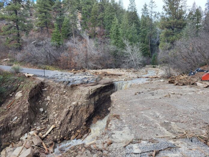
Junction Creek shows how long repairs take. Water eroded the roadbed at mile 0.3 and left less than one lane. The Forest Service opened a temporary lane, and design work on a retaining wall and culvert is underway. Construction will likely begin in early 2027, according to the agency’s Junction Creek update.
Why the Order and the Conditions Page Disagree
A road missing from the closure orders is not automatically open. For example, Burnt Timber 595 left the revised list, yet a Nov. 4 entry on the conditions page still calls it inaccessible because Missionary Ridge 682 stays closed.
Dates also differ. Some conditions entries date to Nov. 4, while the orders took effect Nov. 20. Read each entry’s date before you trust it.
Winter adds a third factor. Many forest roads have begun to close on their Motor Vehicle Use Map winter dates. Moreover, the Forest Service warns against assuming a road passable now stays passable on your way back.
The Nov. 4 mud reports above show why traction matters. Rescue is not readily available, so carry traction boards to free a stuck truck yourself. Our off-road recovery guide covers technique. Use the boards only on open roads, never to push past a closed gate.

MAXTRAX MKII Black Vehicle Recovery Board
Traction boards for getting a stuck truck moving again without a winch or a second vehicle.
- Pair of 45-inch boards with two leashes included
- Owners report use in mud, sand and snow
- Reviewers say the boards resist bending and cracking
- Some buyers say mounting hardware is not included
- The pair weighs about 17 pounds
What This Means for You
Run three checks before you commit to a road. First, find the road number in your district’s order, using the Pagosa map or the Columbine map. Next, read the road’s entry on the conditions page and note its date. Finally, call the flood info line at 970-501-5830 if the entry looks old.


A closed road costs more than a detour. Driving one is a Class B misdemeanor. The conditions page also warns against ruts and road damage, and it says drivers face tickets for damage. Neither the agency nor the counties rescue stranded vehicles.
Camping plans need the same check. Review our Colorado dispersed camping guide before you pick a site. The designated dispersed camping explainer covers the San Juan National Forest Navajo Lake Basin.
Frequently Asked Questions
Do the San Juan road closures apply to ATVs and UTVs?
Yes. Both orders prohibit motorized traffic on every listed road and motorized trail. ATVs, UTVs and dirt bikes follow the same lists as trucks.
How long do the San Juan road closures last?
The orders run until 12:01 a.m. on Dec. 31, 2026, unless the Forest Service rescinds them. However, many roads close earlier for winter under Motor Vehicle Use Map dates.
Who is exempt from the closure orders?
Travelers with permit FS-7700-48 or a written determination stating no permit is required are exempt. Officers and rescue or firefighting personnel on official duty are also exempt.
Is it legal to walk or bike a closed road?
The Forest Service orders allow pedestrians, equestrians and cyclists on these roads at their own risk. Even so, flood damage makes many of them dangerous on foot.
Where do I check San Juan road status?
Start with the Forest Service conditions page, then call the flood info line at 970-501-5830. The Pagosa Ranger District answers at 970-264-2268, and the Columbine Ranger District office in Bayfield answers at 970-884-2515.
Final Thoughts
Dec. 31 marks the end of the orders, not a promise of open roads. Winter closures, repairs and new storms keep changing the list. Check each road number the day before you leave, and carry gear for self-rescue. Turn around when a road looks worse than its entry.
Related Reading