


Quick Facts:
- Topic: Mojave National Preserve road closures and what stays open.
- Start date: Monday, Nov. 16, 2026.
- Project: About 42 miles of Kelso-Cima Road and South Kelbaker Road.
- First closure: South Kelbaker between Kelso and the southern boundary near I-40.
- Also closing: Kelso Dunes and two primitive camping areas.
- Expected finish: 2029, in phases.
- Still open: Hole-in-the-Wall campground and information center, plus most 4WD roads at your own risk.
- Source: National Park Service.
- Best for: Overlanders and 4×4 campers planning Mojave trips this winter.
7 min read
In This Article
Mojave National Preserve Closure Overview
Mojave National Preserve starts a multiyear road rebuild on Monday, Nov. 16. The first closure shuts South Kelbaker Road south of Kelso. Working with the Federal Highway Administration, the National Park Service will rework about 42 miles of Kelso-Cima and South Kelbaker roads. Also, NPS expects the full project to finish in 2029.
Work will run in phases, and NPS says closures will be required throughout the multiyear project. Funding comes partly from the Great American Outdoors Act Legacy Restoration Fund. NPS warns of possible significant added travel time, particularly for motorists traveling through the region, according to its project announcement.
The first phase also closes Kelso Dunes and two primitive camping areas until the South Kelbaker phase ends.
If your next trip runs through this corner of the desert, reroute now. This guide covers what closes, what stays open, and how to adjust your route and supplies.
Pair your trip plan with a printed map of the preserve itself. The National Geographic Trails Illustrated Mojave National Preserve Map names Kelso Depot and the Mojave Road, and it prints on waterproof, tear-resistant paper. Trace your detour on it at home, before the closure changes your usual route.

Mojave National Preserve Map (National Geographic Trails Illustrated Map, 256)
A waterproof, tear-resistant topographic map of the whole preserve, with Kelso Depot and the Mojave Road marked.
What Closes on Nov. 16
South Kelbaker closes between Kelso and the preserve’s southern boundary near I-40. NPS posted the notice on its alerts and conditions page on Nov. 4. Three recreation sites close with the road:
- Kelso Dunes.
- Primitive camping at the dunes.
- The Granite Pass and Kelbaker Boulders primitive camping area.
NPS says all three stay closed until the South Kelbaker phase is complete. However, neither the release nor the conditions page gives an end date for the phase. Later phases will add closures across the rest of the 42-mile project area.
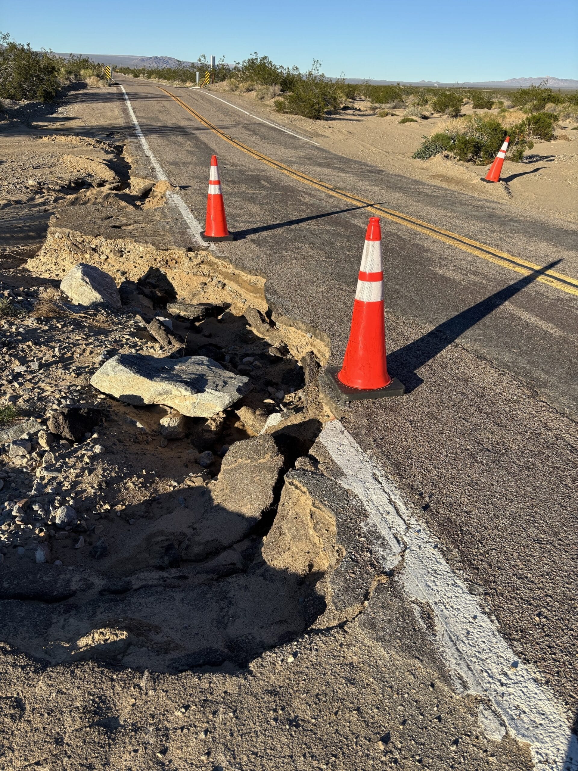
Road damage is the reason for the work. The rebuild widens shoulders, adjusts road alignments, and improves sightlines and tight curves. It also adds drainage work for flooding and measures to protect desert tortoise habitat. An NPS photo of South Kelbaker shows a shoulder washout cutting into the driving lane.
What Stays Open in Mojave National Preserve
Most of the preserve stays open. As of the Nov. 4 update, NPS lists Kelso-Cima, Cima, Kelbaker, Morning Star Mine, Ivanpah and Lanfair roads as open, though South Kelbaker closes on Nov. 16. It also lists all other primary paved roads as open. The information center and campground at Hole-in-the-Wall stay open, along with Mid Hills Campground. Specifically, the first-phase notice names only the stretch south of Kelso, so the Baker approach is unaffected in this phase.
NPS lists its 4WD roads as open, with a warning to travel at your own risk, except Hart Mine Road, which it lists as closed. Many backcountry routes need 8 inches or more of clearance, low-range 4WD and heavy-duty tires. The agency says all-wheel-drive SUVs are not always suited to them, and it lists Mojave Road as 4WD only.
Plan for two limits. NPS has closed the indoor area of Kelso Depot Visitor Center for heating and cooling work. However, the outdoor areas, restrooms and water filling stay open. Meanwhile, NPS reports possible delays of up to one hour at the railroad crossing on Kelbaker near the depot when trains work the siding. It advises extra fuel and drinking water.
Reroute Around the Mojave National Preserve Closure
Your entry point decides how much the closure costs you. NPS directions send I-15 drivers to exit at Baker and drive south 34 miles on Kelbaker to Kelso Depot. This approach sits outside the first closure, but it ends at Kelso Depot, so leave slack for the railroad crossing there. For longer desert loops, use our guide to plan a multi-day desert route around the open segments.
The I-40 approach is different. NPS directions tell drivers to exit 28 miles east of Ludlow and drive north 22 miles to Kelso Depot. This drive runs into the closed segment, so skip it. I-40 drivers should use the Essex Road route below instead, which leads to the information center and campground.
For this route from I-40, NPS directions use Essex Road. Drive north 10 miles to the Black Canyon Road junction, then 10 miles north on Black Canyon Road. NPS reports debris and washouts near the junction. It also says to ignore GPS directions onto dirt roads.
Navigation needs a backup because cell service is unreliable or absent across most of the preserve. NPS suggests a paper map or atlas. Set your GPS to Kelso, because using Mojave, California takes you 168 miles away from the park.
What This Means for You
Start with where you planned to sleep. Dunes camping is gone for now, so switch to an open campground. Our list of free dispersed camping in Southern California offers other desert options.
Next, check your route. Anyone using Kelbaker as a shortcut between I-15 and I-40 loses it south of Kelso. With no gas stations in the preserve, count your approach against your tank: 34 miles from Baker to Kelso Depot, or 20 miles from I-40 on the Essex Road route. Run the numbers with our guide to fuel range planning for remote routes before you leave pavement.
Finally, verify before every trip. NPS directs travelers to its conditions page for current road conditions, closures and project updates. Check it again the morning you leave.
Respect the barricades. NPS says rangers patrol closed roads, turn travelers back and issue citations.
Pack for Longer Drives
The preserve sells no gas, and no station sits where Kelbaker Road meets I-40. Fill up in towns such as Barstow, Baker, Ludlow, Fenner or Needles, or near 29 Palms or Amboy, as the agency suggests. Likewise, no food or drinks are sold inside the preserve.
Water is the next limit. The NPS conditions page lists potable water at the Kelso Depot restroom building and at the Hole-in-the-Wall Visitor Center and Campground. Its camping page also lists water at Black Canyon Group and Equestrian campgrounds, and none at Mid Hills. Carry more than your trip needs, because refills sit at only a few stops.
Tires deserve attention too. NPS lists Fort Piute as 4WD only, with no street tires, because the rocks are sharp and likely to puncture a tire. The agency also warns of rocky, sandy and other tire-puncturing terrain off pavement, so carry a plug kit and a way to reinflate.
Load two items for the longer detours: the Igloo 6-gallon water container and the Tooluxe 35-piece tire plug kit. The Igloo carries drinking water between the few refill points NPS lists. For sharp rock on roads like Fort Piute, the Tooluxe plugs a tread puncture.
Desert supplies for the longer detour


Tooluxe 50002L -35 Piece Tire Repair Universal Heavy Duty Tire Repa…
Final Thoughts
Only the first phase has a start date. NPS has detailed only this stretch of South Kelbaker, so every later phase is a reason to recheck the conditions page before a trip.
Dunes campers lose their first choice, not the whole preserve. Other campgrounds stay open, as do the roads NPS lists, so a winter trip still works with a new base camp.
Therefore, plan your detour, pack extra supplies, and recheck the conditions page the morning you leave.
FAQ
Is Mojave National Preserve closed?
No. NPS lists the campgrounds, Kelso-Cima Road and its 4WD roads as open, except Hart Mine Road. On Nov. 16, South Kelbaker south of Kelso and three recreation sites close, and later phases will add closures.
When does the South Kelbaker closure start?
It starts Monday, Nov. 16, 2026, as the first phase of a project NPS expects to finish in 2029. NPS has not published an end date for this phase.
Is Kelbaker Road closed?
Part of it. South Kelbaker closes on Nov. 16 between Kelso and the preserve’s southern boundary near I-40. The first-phase notice does not name the northern approach from Baker, and NPS directions still send I-15 drivers along it.
Will Kelso Dunes reopen soon?
Not on a known date. NPS says the dunes stay closed until the South Kelbaker phase is complete. Check the NPS conditions page before you plan around it.
How do I reach Hole-in-the-Wall from I-40?
Take Essex Road north 10 miles to the Black Canyon Road junction. Then drive 10 miles north on Black Canyon Road to reach the information center and campground.
Where do I buy gas near Mojave National Preserve?
Gas is not sold inside the preserve. NPS suggests filling up in Barstow, Baker, Cima, Primm, Jean, Henderson or Las Vegas on the north side, and near 29 Palms or Amboy, or in Fenner or Ludlow, on the south side. Needles and Barstow are farther but also have gas.
Related Reading