




Quick Facts:
- Trail: Utah High Desert Trail (proposed)
- Length: About 810 miles under the preferred Alternative B
- Counties: Box Elder, Tooele, Juab, Millard, Beaver, Iron, Washington
- Managing agency: Bureau of Land Management, Utah State Office
- Review status: Draft Environmental Assessment; public comment closed June 16, 2026
- Trail type: Existing public roads and routes, no new construction
- Users: OHV, overlanding, adventure motorcycle, equestrian, hiking, mountain biking
- Best for: Long-distance OHV and overland travel across western Utah
7 min read
In This Article
Utah High Desert Trail Overview
The Utah High Desert Trail is a proposed long-distance OHV route across western Utah. Under the preferred plan, it would link roughly 810 miles of existing roads and trails into one signed, border-to-border corridor. Here is the part riders notice: the project would build no new trail miles. Instead, it would formally designate routes already open to the public today, which makes those roads far harder to close later. State and federal partners are advancing the plan through federal review right now.
For off-road and overland travelers, the appeal is scale and variety. The corridor would cross high desert basins, mountain ranges, red rock canyons, and alpine forest. Because much of the route sits at lower desert elevations, riders reach long sections during spring, fall, and even winter. As a result, the trail spreads visitation across the year rather than concentrating it in summer.
The Bureau of Land Management also leads the federal review, working with the Utah Division of Outdoor Recreation, counties, and recreation groups. Right now the project sits in environmental review, and a key public comment window has already closed. Below, you get the route, the numbers, the review status, and the realistic timeline for what comes next.
High Desert Trail Key Facts
Here are the core details at a glance, drawn from BLM and Utah Division of Outdoor Recreation project materials.
| Detail | Value |
|---|---|
| Official name | High Desert Trail (HDT) |
| Preferred length | About 810 miles (Alternative B) |
| Core riding opportunities | More than 600 miles |
| Counties | Box Elder, Tooele, Juab, Millard, Beaver, Iron, Washington |
| Lead agency | BLM Utah State Office |
| NEPA number | DOI-BLM-UT-0000-2026-0002-EA |
| New trail miles | None; existing routes only |
| Comment period | June 2 to June 16, 2026 (closed) |
The Route Across Seven Counties
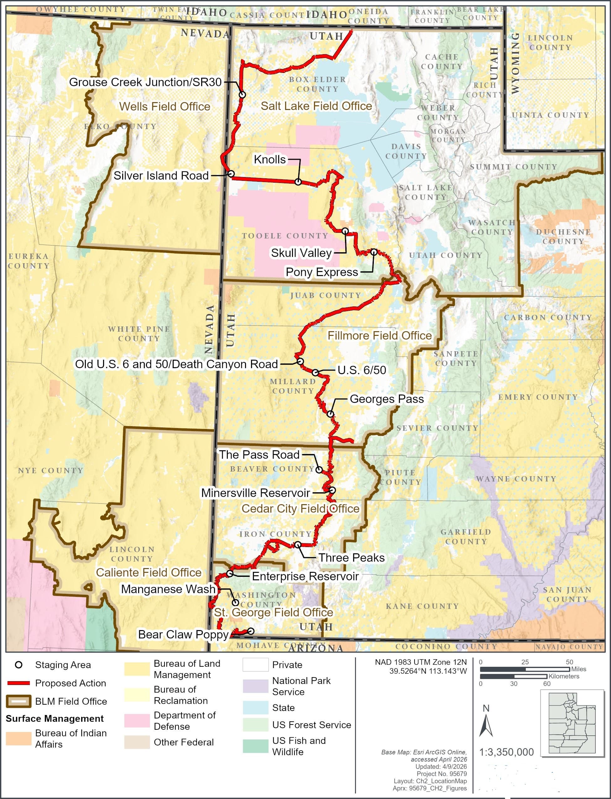
The proposed corridor runs north to south through the western half of the state. Specifically, it connects Box Elder, Tooele, Juab, Millard, Beaver, Iron, and Washington counties. Each segment highlights different terrain, from high-desert sagebrush valleys in northern Box Elder County to red rock country closer to Washington County.
Because the route strings together existing roads, the experience changes constantly. For example, one day you cross open desert flats. The next, you climb into forested mountains. For trip planning, offline navigation matters, since cell service drops fast in this country. Our roundup of the best off-road navigation apps covers the tools riders rely on for routes like this.
Camping also shapes any multi-day run. Much of the corridor passes through BLM land where dispersed camping is allowed. If you want a head start on legal sites near the route, our guide to free dispersed camping in Utah lays out the rules and the best areas.

Why You See 600 Miles and 810 Miles
Coverage of this project uses two different numbers, and the gap confuses readers. The Utah Division of Outdoor Recreation describes a trail “spanning over 600 miles.” Meanwhile, the BLM and supporters cite roughly 810 miles. Both figures are correct, because they measure different things.
The 600-plus figure reflects the core riding opportunities along the spine of the route. The 810-mile figure, by contrast, reflects the full designated system under Alternative B, including connectors and supporting segments. In short, 600 is the heart of the trail, while 810 is the complete network the preferred plan would formalize. Alternative C, a shorter option, would designate fewer miles.
Where the BLM Review Stands
The project moves through a federal environmental review under the National Environmental Policy Act. The BLM Utah State Office prepared a Draft Environmental Assessment, filed under NEPA number DOI-BLM-UT-0000-2026-0002-EA. During the review, the agency opened a public comment period from June 2 to June 16, 2026. The agency also held two virtual public meetings on June 8 and June 9.
The Draft EA studies several alternatives. Alternative A is no action, meaning current management with no formal designation. The preferred option, Alternative B, designates the longer 810-mile route with an OHV open designation. A shorter option, Alternative C, formalizes fewer miles. You will find the proposal and the alternatives on the BLM ePlanning project page and the Utah Division of Outdoor Recreation page.
The comment window has already closed. Earlier coverage urged readers to submit comments by June 16, yet the date has passed. Understanding the designation process helps here, because the same “closed unless open” logic governs many public routes. Our explainer on how route designations work walks through how agencies map and manage legal travel.
What It Means for OHV Access
Supporters frame the trail as a way to lock in access. Since the plan designates routes already open, formal recognition would make those roads harder to close later. For riders who have watched trails disappear, durability is the real prize. Recent Mojave OHV trail closures show how quickly access shrinks when routes lack clear designation.
Economic development also drives much of the local support. A signed long-distance route would send more travelers through small towns for fuel, food, and lodging. The plan also calls for improved trailheads, staging areas, signage, and wayfinding kiosks. Consequently, backers in rural counties see tourism dollars following the trail markers.
The corridor is multi-use by design. Beyond OHV riders, it would serve overlanders, adventure motorcyclists, equestrians, hikers, and mountain bikers in appropriate segments. For overland travelers, the payoff is a single mapped backbone connecting the state’s remote country.
Support and Opposition
The proposal splits the recreation and conservation communities. On one side, the BlueRibbon Coalition backs the longer Alternative B. This access advocacy group argues the route delivers the most recreation value and the biggest economic lift for rural towns. It lays out the reasoning on the BlueRibbon Coalition site.
On the other hand, conservation advocates push back. The Southern Utah Wilderness Alliance opposes a heavily promoted point-to-point route, warning it would funnel traffic past designated wilderness and into desert tortoise habitat. You will find its position on the SUWA site. More access versus less disturbance is the trade-off the BLM now has to resolve.
High Desert Trail vs. the Paiute Trail
Supporters often compare the High Desert Trail to Utah’s Paiute Trail, and the comparison helps set expectations. For instance, the Paiute system in central Utah offers a 275-mile main loop plus more than 1,000 miles of connected side trails, and it draws steady tourism to nearby towns. Backers hope the new corridor delivers similar benefits across the region.
The two projects differ in important ways, though. While the Paiute Trail is established and well known, the new corridor remains a proposal under review. Its routes sit largely in mountain terrain, whereas the new corridor leans heavily on lower desert country with longer seasons. For riders, the practical takeaway is simple: the route would add a drier, longer-season alternative to an already strong Utah lineup.
What Happens Next
With the comment period closed, the BLM now reviews and responds to public input. After this step, the agency finalizes the Environmental Assessment and issues a decision. For an EA, the common outcome is a Finding of No Significant Impact paired with a decision record. If the review surfaces larger concerns, the agency would expand its analysis instead.
The BLM has not announced a public date for a final decision. Therefore, the realistic next milestone is the agency’s response to comments and a final EA. Riders who want to follow the timeline should watch the BLM ePlanning page and the Utah Division of Outdoor Recreation project page for updates.
If the agency approves Alternative B, designation would formalize about 810 miles of existing routes and trigger the signage and staging improvements. For now, the roads remain open under current management, so the country is still ridable while the paperwork moves. The decision will shape how one of the West’s largest proposed OHV corridors takes final form.
Frequently Asked Questions
What is the Utah High Desert Trail?
It is a proposed long-distance OHV route across western Utah. The plan would link existing public roads and trails into one signed corridor of roughly 810 miles under the preferred option. The project designates current routes rather than building new ones.
How long is the route?
Under the preferred Alternative B, the designated system runs about 810 miles. The core riding opportunities along the route exceed 600 miles. The two numbers describe the full network and the central spine, respectively.
Is the trail open to ride now?
The roads and trails in the proposal are already open to the public under current management. The designation process would add signage, staging areas, and formal recognition. As a result, riders use the existing routes today while the review continues.
Did the BLM comment period close?
Yes. The public comment period for the Draft Environmental Assessment ran from June 2 to June 16, 2026, and it has closed. The BLM now reviews comments before finalizing the assessment and issuing a decision.
Which counties does the route cross?
The proposed corridor crosses seven western Utah counties: Box Elder, Tooele, Juab, Millard, Beaver, Iron, and Washington. Each segment features distinct terrain, from desert basins to alpine forest.
Who manages the project?
The Bureau of Land Management Utah State Office leads the federal review. The agency works with the Utah Division of Outdoor Recreation, county governments, and recreation groups on planning and designation.