


Quick Facts: This guide shows you how to read a topographic map for off-road travel.
- Topic: How to read a topographic map for off-road travel
- Skill level: Beginner
- Time to learn: About 20 minutes
- Tools needed: A topographic map, a baseplate compass, an optional GPS app
- Key concept: Contour lines show elevation and the shape of the land
- Common scale: 1:24,000 (USGS 7.5-minute quad)
- Best for: Overlanders, hunters, hikers, and backcountry drivers
9 min read
In This Guide
- How to Read a Topographic Map: Overview
- Topographic Map Anatomy at a Glance
- What a Topographic Map Shows
- Reading Contour Lines and Elevation
- Spotting Peaks, Valleys, and Saddles
- Map Scale and Measuring Distance
- Topographic Map Symbols and Colors
- Magnetic Declination and Your Compass
- Reading a Topographic Map Off-Road
- Where to Get Topographic Maps
- Common Map-Reading Mistakes
- How to Read a Topographic Map With Confidence
- Frequently Asked Questions
How to Read a Topographic Map: Overview
Learning how to read a topographic map turns a confusing sheet of brown squiggles into a clear picture of the land. I first learned the skill in 1991 at Fort Leonard Wood, Missouri, during Army boot camp. For overlanders, those lines reveal where a trail climbs, where a wash cuts deep, and where a ridge blocks your path. A GPS app helps, yet a paper map never loses signal or battery. This guide teaches the skill from the ground up, with field notes from boot camp to the backcountry.
These skills fit anyone heading off pavement. Hunters, hikers, and backcountry drivers all rely on the same core skills. Map reading also ranks high in any beginner’s guide to overlanding. Once you understand contour lines, scale, and symbols, you read any topo map quickly.
I keep a paper quad in the ZR2 next to a phone running topo layers. On an earlier Sierra climb in the Gladiator, the contour spacing warned me the grade steepened past the switchback. Because I read it early, I aired down and picked a line before the hard section. This habit has saved me more than once.
Topographic Map Anatomy at a Glance
Every topographic map shares the same building blocks. Knowing how to read a topographic map starts with these six, and the rest follows. The table below names each part and what it tells you.
| Element | What it tells you |
|---|---|
| Contour lines | The shape and steepness of the land |
| Contour interval | The vertical distance between two adjacent lines |
| Index contours | Bold, labeled lines marking elevation |
| Map scale | Real distance per inch (1:24,000 means 1 inch equals 2,000 feet) |
| Legend and symbols | Roads, trails, water, buildings, and vegetation |
| Declination diagram | The gap between true north and magnetic north |
What a Topographic Map Shows
When you read a topographic map, you see the three-dimensional shape of the ground on a flat sheet. Unlike a road map, it records elevation, slope, water, and land cover. Notably, contour lines carry most of this information. Symbols and colors fill in the rest, from creeks to jeep trails.
The standard United States topographic map is the USGS 7.5-minute quadrangle at 1:24,000 scale. Each quad covers a small area in fine detail, which suits trail navigation. For wider planning, smaller scales like 1:100,000 cover more ground with less detail. Match the scale to your trip.
Read the margins first. The map name, scale, contour spacing, and publication date all sit around the edge. Older maps still show terrain well, yet roads and trails change, so check the date before you rely on it.
Reading Contour Lines and Elevation
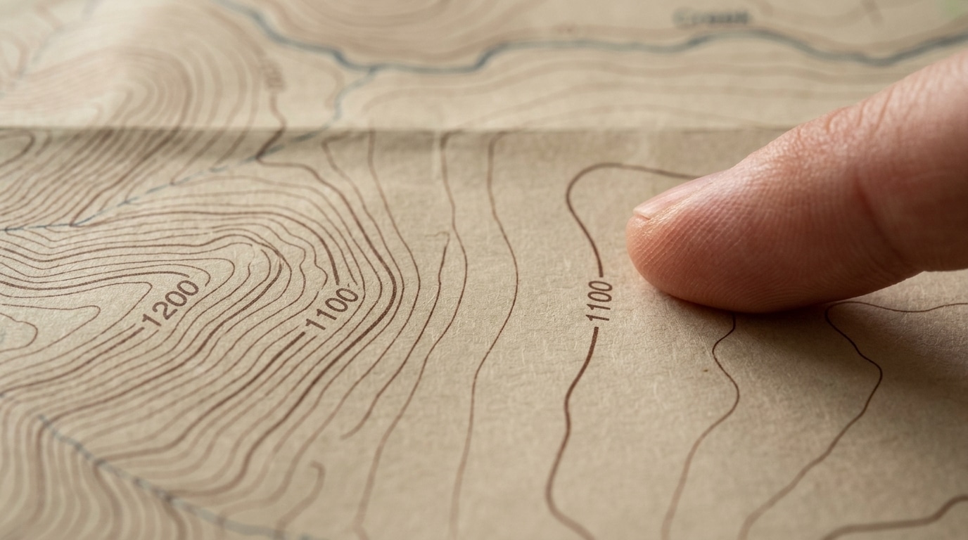
Contour lines connect points of equal elevation. Follow one line and you stay level the whole way. Conversely, step across lines and you gain or lose height. Each step between lines covers a set height, often 40 feet on a 1:24,000 quad.
Spacing is the key signal. When lines sit close together, the slope is steep. Where they spread apart, the ground is gentle or flat. As a result, a cluster of tight lines means a cliff or a wall you should route around.
Index contours make reading faster. These bold lines appear every fifth contour and carry an elevation label. Find one, read its number, then count lines up or down to learn any point’s height. Because the labels repeat across the map, you orient elevation at a glance.
Spotting Peaks, Valleys, and Saddles
Contour shapes reveal specific landforms. A set of closed loops, each smaller than the last, marks a hill or peak. In particular, the highest ring sits at the top. Read the labels to confirm the summit elevation.
Valleys and ridges both show as V or U shapes, so direction matters. When the V points uphill toward higher contours, you are looking at a valley or drainage, and water runs through its base. If the V points downhill instead, you found a ridge. This single rule prevents many wrong turns.
A saddle looks like an hourglass between two high points. It marks the low pass over a ridge, which often carries the easiest route across. Hunters and drivers both aim for saddles to cross terrain with less climbing.
Map Scale and Measuring Distance
Map scale links the paper to the real world. At 1:24,000, one inch on the map equals 2,000 feet on the ground. Meanwhile, the scale bar in the margin lets you measure distance without math. Lay a strip of paper along your route, mark the bends, then compare it to the bar.
Distance on the map ignores climbing, so a short trail with tight contours takes longer than it looks. Count the index contours your route crosses to size up the effort. On foot, a common guide adds about one hour for every 2,000 feet of climb on top of your flat-ground pace. In a vehicle, each band of tight contours means low range and a careful crawl, so pad your time.
Topographic Map Symbols and Colors
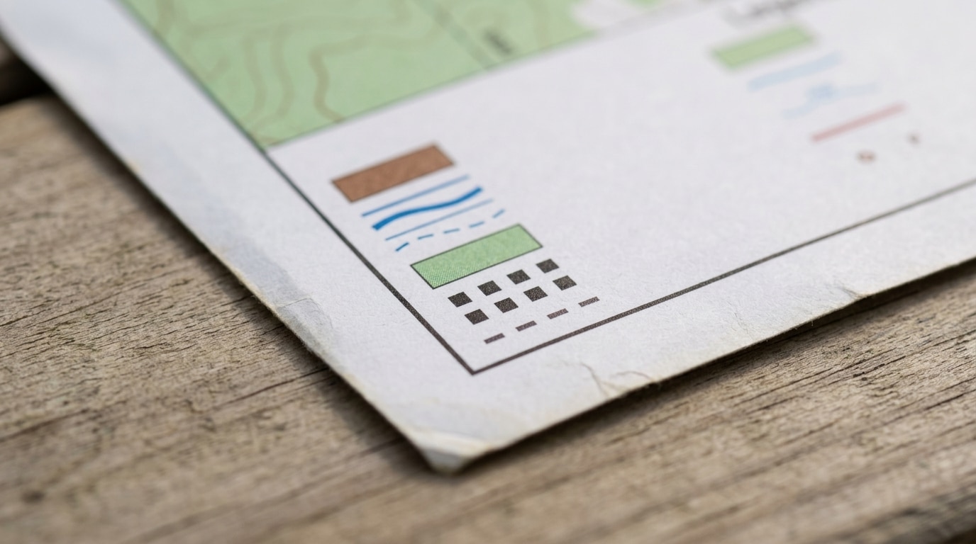
Topographic map symbols pack a lot into small marks. Color is the fastest cue. For example, brown lines show contours and relief. Blue shows water, from rivers to springs. Green marks vegetation, while white shows open ground.
Black marks human features such as buildings, trails, and place names. Red shows major roads and survey lines. Dashed lines signal trails and unimproved roads, so a double dashed line usually means a rough track a high-clearance rig handles. Learn the legend on each map, since publishers vary the details.
A few topographic map symbols repeat everywhere. For instance, a small black square is a building, a circle with a flag is a school, and tight blue lines mark marsh. When a symbol stumps you, the margin legend defines it.
Magnetic Declination and Your Compass
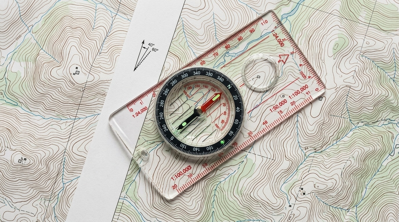
A compass points to magnetic north, but your map aligns to true north. The gap between them is magnetic declination, and it shifts with location and time. In addition, your map margin shows a small diagram with the local angle. Ignore it and your bearings drift off by miles over distance.
Adjust for declination before you trust a bearing. Many baseplate compasses let you set the angle once. To orient the map, lay the compass on it, then rotate the map until north lines up with the needle and declination. Now the paper matches the land in front of you.
Reading a Topographic Map Off-Road
Off the pavement, knowing how to read a topographic map does more than keep you found. Before a trip, I trace the route and read every contour band for climbs and descents. For example, tight bands near a creek warn of a steep, washed-out crossing. Wide bands promise easy miles.
Pair the paper map with your phone for the best of both. I run topo layers in an app and keep a printed quad as backup, so the two cover each other’s weak spots. For app picks, our guide to off-road GPS apps breaks down the options. When the trail forks, the map confirms which drainage to follow.
A topo map shows terrain, not legal access, so carry the right road map too. The agency Motor Vehicle Use Map lists which roads are open, and our guide to legal dispersed camping explains how to read one. To plan real terrain, I pair a quad with our rundown of off-road trails in California.
Where to Get Topographic Maps
You have more sources for topographic maps now than ever. The USGS offers free quad downloads through its online map viewer, ready to print at home. In addition, visitor centers and ranger stations often sell the local quads too. For a trail-ready copy, print on waterproof paper or seal the sheet in a gallon bag, and many overlanders laminate a favorite quad and mark routes with a grease pencil.
Digital tools add another layer. Apps such as CalTopo and onX Offroad render the same contour data on your phone, then let you download regions for offline use. onX also shows public and private land boundaries, which helps you stay legal near mixed ownership. I build a route at home on a big screen, sync it to the phone, and print a paper backup for the glovebox. Because batteries die and screens crack, the printed sheet earns its space.
Match the map to the trip before you leave. A weekend in one canyon needs a single quad. For a multi-day route, gather every quad along the line, or print a wider 1:100,000 sheet for the overview. Store the sheets flat or rolled so the folds do not wear through the ink. Either way, check the publication date so new roads and closures do not surprise you.
Cost stays low overall. The USGS downloads are free, while apps run on a yearly subscription bundling imagery, weather, and trail data. For most drivers, one paid app plus a few printed quads covers every trip.
Common Map-Reading Mistakes
A few mistakes trip up new map readers. First, people confuse valleys and ridges, then follow a drainage the wrong way. Always use the V rule to check direction. Second, they forget declination and march off their bearing.
Reading distance without elevation is another trap. A two-mile leg with stacked contours eats far more time than two flat miles. Skipping the map date causes trouble too, since a new road or a washout never appears on an old print. The fastest way to learn how to read a topographic map is to practice on ground you already know.
How to Read a Topographic Map With Confidence
You now know how to read a topographic map: contour lines for shape, spacing for steepness, scale for distance, and symbols for everything else. Start with a quad of a place you know well. Walk or drive a familiar trail while you track your position line by line.
With a few trips, the lines turn into terrain in your mind. Pair the paper skill with a GPS app, keep both in the rig, and you navigate with confidence when the signal drops. Above all, the map rewards every minute you spend learning it.
Frequently Asked Questions
What does a topographic map show?
A topographic map shows the shape of the land, including elevation, slope, water, vegetation, and human features. Contour lines carry the elevation detail, while colors and symbols mark everything else. Together they let you picture terrain you have not seen yet.
What do contour lines mean?
Contour lines connect points at the same elevation. Close spacing means steep ground, while wide spacing means gentle terrain. The contour interval, listed in the margin, tells you the height between each line.
What is a contour interval?
A contour interval is the fixed vertical distance between two adjacent contour lines. On a 1:24,000 USGS quad, it is often 40 feet, though steep maps use larger values. Check the number printed in the bottom margin before you read elevation.
What map scale is best for off-road navigation?
For detailed trail work, the 1:24,000 USGS quad gives the best balance of coverage and detail. Larger areas suit a 1:100,000 map, which shows less. Many drivers carry both: a wide map for planning and a quad for the hard sections.
How do I adjust for magnetic declination?
Find the declination angle in the map margin, then set it on your baseplate compass or add it by hand. True north and magnetic north differ by location, so the angle changes as you travel. Without the fix, your bearing drifts wider the farther you go.
Is it hard to learn how to read a topo map?
No. Most people learn how to read a topo map in an afternoon of practice. Start with contour lines and scale, then add symbols and declination, and walk a familiar trail to lock it in. The skill sticks fast once you connect lines to real ground.